
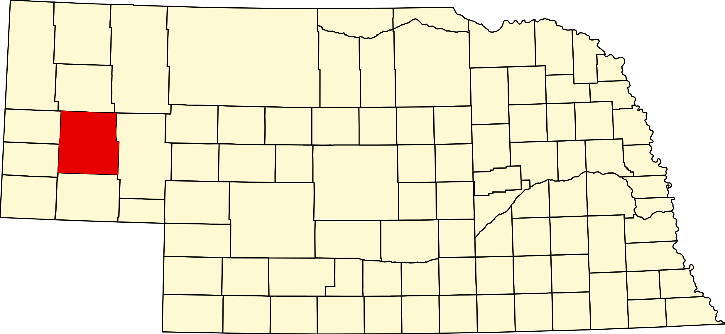
Morrill County, Nebraska
County Seat: Bridgeport
Founded: 1908
Named For: Charles Henry Morrill, president of the Lincoln Land Company
License Plate Prefix: 64
Population: 4,555 (2020 census)
Area: 1,424 sq mi
History
Morrill County was established in 1908 from the western portion of Cheyenne County and named after Charles Henry Morrill, a prominent land developer and president of the Lincoln Land Company. Settlement expanded along the North Platte River, where irrigation transformed the region into productive farmland. Bridgeport became the county seat and grew into a key agricultural and transportation hub.
The county’s history is closely tied to ranching, farming, and the development of early trails and railroads. The Oregon Trail passed through the region, leaving behind preserved ruts and historic markers that highlight the area’s frontier heritage.
Geography
Location: Western Nebraska along the North Platte River
Landscape: River valleys, irrigated farmland, prairie grasslands, and historic trail corridors
Adjacent Counties:
- Box Butte County (north)
- Sheridan County (northwest)
- Garden County (east)
- Cheyenne County (south)
- Scotts Bluff County (west)
Culture & Landmarks
- Courthouse & Bridgeport Historic District – Early 20th‑century architecture and community landmarks.
- Oregon Trail Sites – Preserved wagon ruts and interpretive markers across the county.
- North Platte River Valley – Scenic corridor supporting agriculture, wildlife, and recreation.
Notable Communities
- Bridgeport – County seat and largest community.
- Bayard – Community near Chimney Rock and the North Platte River.
- Angora – Rural settlement with strong ranching roots.
- Broadwater – Incorporated village along the North Platte River.
- Northport – Historic unincorporated community.
- Redington – Historic unincorporated community.
Events & Attractions
- Bridgeport Trail Days – Celebrates local heritage with parades, music, and community events.
- Oregon Trail Recreation – Hiking, sightseeing, and historic exploration.
- Agricultural Fairs & Festivals – Events highlighting farming, ranching, and rural traditions.
Living in Morrill County
Morrill County offers a rural lifestyle centered around agriculture, small‑town community life, and historic landscapes. Bridgeport and Bayard provide essential services, while the North Platte River valley supports farming, recreation, and wildlife. Residents value the area’s quiet pace, strong community ties, and deep connection to Nebraska’s frontier history.
Outdoors — Camping, RV, Hunting & Fishing
Morrill County is trail country. Chimney Rock and Courthouse and Jail Rocks are the two most recognised landmarks on the whole Nebraska stretch of the Oregon–California Trail, and Bridgeport State Recreation Area gives you five lakes and 80 campsites within the county seat.
Before you plan a trip: the Morrill Fire. Between 12 and 25 March 2026 a fire that started northeast of Bridgeport in 75 mph winds burned east through Garden, Grant, Arthur and Keith counties and reached 642,029 acres — the largest wildfire in Nebraska history. One person died, numerous structures were lost, and the eastern part of Morrill County is a changed landscape. Anyone planning a hunt here should check the current Public Access Atlas and call the Game and Parks office at Alliance or Bridgeport before committing to a season — habitat, access roads and landowner willingness have all shifted.
Chimney Rock National Historic Site. 9822 County Road 75, Bayard; (308) 586-2581. About two miles south of Bayard. Designated a National Historic Site on 9 August 1956.
The single most common error about this place: Chimney Rock is administered by History Nebraska, not the National Park Service. It is one of very few National Historic Sites the Park Service does not run — so an America the Beautiful pass will not get you in, and NPS hours do not apply.
- Hours: 1 May to 30 September, daily 9 a.m. to 4 p.m. Mountain. 1 October to 30 April, Tuesday through Saturday 9 to 4, closed state holidays.
- Admission: adults 19 and over $5, children 5–18 $3, four and under free. Free for History Nebraska members, college students, and active-duty military with ID from 16 May to 7 September. Museums for All with SNAP EBT: $2 adults, $1 children.
- The Ethel S. and Christopher J. Abbott Visitor Center holds the pioneer-migration exhibits and the gift shop. There is no maintained trail to the spire and no camping on site — the visitor center is the visit.
- The rock rises about 325 feet above the valley floor with a 120-foot spire.
Courthouse and Jail Rocks. About five miles south of Bridgeport, National Register listed in 1973, roughly 917 acres. The formation stands at 4,050 feet, some 400 feet above the North Platte valley. Four historic routes passed here — the Oregon–California Trail, the Mormon Trail, the Pony Express and the Sidney–Deadwood Trail — and emigrants would detour up to five miles just to see them. There is a Pony Express station site southeast on Pumpkin Creek. Public historic site, informal access, no visitor center and no fee.
Bridgeport State Recreation Area. 100 Recreation Road, Bridgeport; (308) 783-2911. About 326 acres with 78 acres of water across five sandpit lakes — Center, Northwest, East and West among them.
- 80 basic campsites, all first come first served, no reservations. Ground grill and picnic table per site, with waterfront, grass and secluded options.
- Dump and fill station: yes, near the park entrance.
- No electric hookups, no showers, and the restroom is an accessible vault latrine. For an RV this is a dry-camping stop with a dump station, not a hookup park.
- Pay at Iron Ranger self-service boxes — cash or checks only. Basic camping is $15 a night in 2026 ($10 off-season from mid-October through April), plus a park entry permit: $7 daily or $35 annual on Nebraska plates, $14 or $70 out of state.
- Boating rules matter here. On Center Lake all boats are permitted but travel must be counterclockwise, with no-wake zones by the ramp and the swimming area. On East and West Lakes it is non-powered vessels and electric motors only.
- Fishing: seasonally stocked rainbow and cutthroat trout, walleye, northern pike, largemouth bass, bluegill, crappie, yellow perch and channel catfish. Swimming beach on Center Lake, plus a reservable amphitheater, picnic tables, grills, horseshoe pits and a playground.
Chimney Rock Pioneer Crossing. 10012 Road 75, Bayard; (308) 631-4700. 15 pull-through sites and a cabin at the base of Chimney Rock, full hookups with water, power and sewer at the site and an on-site dump station. Open all year. Twenty miles east of Gering on NE-92 or twelve miles west of Bridgeport on US-26. Gift shop, ice cream and the Settlers Trading Post. Rates run about $38 to $45.
Bayard City Park, 249 E 11th St. — three back-in sites with electric and water, no dump station. Reported as free for the first two nights then $10, gravel and fairly level, suiting RVs up to about 35 feet, with public restrooms across the street. The detail here comes from an older visitor report — call the city before relying on it.
Public fishing water. Bridgeport SRA (78 acres over five lakes) is the main one. Bridgeport City Pond (1.25 acres, renovated 2023) holds bluegill, channel catfish and largemouth bass. Note that the “Morrill Sandpits” on the state list are named for the village of Morrill, which is in Scotts Bluff County, not Morrill County.
Hunting. Chet and Jane Fliesbach WMA — still widely called Facus or Faucus Springs — is 433 acres of wetland and upland near Chimney Rock just east of the North Platte, donated through The Nature Conservancy and managed for deer, dove, pheasant and waterfowl. It holds both freshwater and saltwater marsh, is a sandhill crane nesting site, and is important brood habitat for shorebirds. No other WMA is confirmed in the county, so Open Fields and Waters walk-in is the practical fallback across most of Morrill. Game: mule deer, whitetail, pronghorn, turkey, pheasant, dove and waterfowl on the river. Morrill is one of the seven bighorn sheep counties, though the hunt is one auction and one lottery permit a year statewide.
Trail-era history on the ground. The Camp Clarke Bridge site west of Bridgeport carried the Sidney–Black Hills gold road over the North Platte on a long wooden toll bridge. The Mud Springs Pony Express Station and the Rush Creek Battlefield of 1865 near Broadwater give Morrill County one of the densest concentrations of trail-era conflict and communication sites in Nebraska.
Morrill County at a Glance
Morrill County, Nebraska — created 3 November 1908, one of Nebraska’s last counties, when Cheyenne County voters approved dividing off the northern portion. Named for Charles Henry Morrill, president of the Lincoln Land Company — the Burlington’s townsite subsidiary, the same firm that platted Scottsbluff and bought Hemingford its courthouse. County seat Bridgeport, established in 1899 when the Burlington built through and named for its bridge over the North Platte. Bayard physically relocated to its present site in 1900 to meet the same line. Population peaked at 9,950 in 1930 and the county has lost more than half of that since. 137 listings across 6 towns.
Getting there: US-26 and US-385 converge at Bridgeport and share the river bridge; Highway 92 also passes through, and NE-88 runs west into Banner County. Morrill is the only Panhandle county on both the Western Trails Scenic and Historic Byway and the 385 Gold Rush Byway. BNSF main line. Mountain Time.
For visitors: the North Platte valley cuts through the middle of low rolling tableland, and the trail-era erosional remnants stand off its south rim — Chimney Rock, Courthouse Rock and Jail Rock. Emigrants on four separate historic routes passed here, and Morrill County holds one of the densest concentrations of trail-era sites in the state: the Camp Clarke Bridge on the Sidney–Deadwood road, the Mud Springs Pony Express Station, and the Rush Creek Battlefield of 1865. Bridgeport SRA has 80 campsites and five sandpit lakes. Chimney Rock is run by History Nebraska, not the National Park Service — $5 adults, open daily in season.
Recent history visitors should know: the Morrill Fire of 12–25 March 2026 started northeast of Bridgeport and became the largest wildfire in Nebraska history at 642,029 acres, burning east across five counties. The eastern part of the county is a changed landscape.
Morrill County · Panhandle · Highway 92 Corridor · Explore Nebraska
Vehicles registered in Morrill County carry license plate number 64. See what every Nebraska county number means.
Morrill County Businesses & Places
137 listings in Morrill County.
Click a category to see the businesses.
Eat & Drink (10)
- Bobbi Jo's Branding Iron — American Restaurant, Bayard
- BurgerWerx — American Restaurant, Bridgeport
- Corner Cafe — Cafe / Coffee Shop, Bayard
- Daily Dose Coffee — Cafe / Coffee Shop, Bayard
- Frankies Bar N Grill — Bar & Grill, Bridgeport
- Karette Drive-In — Drive-In, Bridgeport
- Mi Puerto — Mexican Restaurant, Bridgeport
- Simple Co. Coffeehouse & Floral Shop — Cafe / Coffee Shop, Bridgeport
- Subway – 111 E 8th St, Bridgeport — Subway, Bridgeport
- The Rock Brew & Bakery — Bakery, Bayard
Stay (5)
- Chimney Rock Pioneer Crossing — RV Park, Bayard
- Cobblestone Inn & Suites - Bridgeport — Hotel, Bridgeport
- Landmark Inn — Hotel, Bridgeport
- Meadowlark Motor Inn & Restaurant — Hotel, Bridgeport
- Motel West Way — Hotel, Bridgeport
Outdoors & Recreation (6)
- Arnold Trupp WMA — Public Hunting Areas & WMAs, Nebraska
- Bridgeport State Recreation Area — Campgrounds & RV Parks, Bridgeport
- Chet and Jane Fliesbach WMA — Public Hunting Areas & WMAs, Nebraska
- Chimney Rock Golf Course — Golf Course, Bayard
- Chimney Rock Pioneer Crossing — Campgrounds & RV Parks, Bayard
- Meadowlark Annex RV Park — Campgrounds & RV Parks, Bridgeport
Places to Visit (4)
- Bayard Depot Museum — Specialty Museums, Bayard
- Bridgeport State Recreation Area — State Recreation Areas, Bridgeport
- Chimney Rock Museum — Specialty Museums, Bayard
- Pioneer Trails Museum — History & Heritage Museums, Bridgeport
Events & Venues (5)
- Chimney Rock Pioneer Days — Local Celebration, Bayard
- Flex Fitness 2.1 — Gym, Bayard
- Morrill County Fair — County Fair, Bridgeport
- Morrill County Fairgrounds — Fairground, Bridgeport
- The Vault Studio & Events — Event Venue / Banquet Hall, Bayard
Health & Emergency (5)
- Chimney Rock Chiropractic — Chiropractor, Bayard
- Chimney Rock Medical Center — Medical Clinic, Bayard
- Morrill County Hospital Clinic/Post — Medical Clinic, Bridgeport
- Nein Pharmacy and Gifts — Pharmacy, Bridgeport
- Prairie Therapeutic Massage — Massage, Bayard
Travel Services (1)
- Morrill County Visitors Committee — Bridgeport
Shopping & Gifts (5)
- Al's Market — Grocery, Bayard
- Dollar General - Bayard — Dollar Store, Bayard
- North of the Rock Designs — Gift shop, Bayard
- Serda-Fide Glass — Glass & Mirror Shop, Bayard
- Tiger Paws — Retail, Bayard
Government & Resources (29)
- Bayard Fire Department — Fire Station, Bayard
- Bayard Housing Authority — Housing Authority, Bayard
- Bayard Police Department — Police Station, Bayard
- Bayard Post Office — Post Office, Bayard
- Bayard Public Library — Libraries, Bayard
- Bayard Senior Center — Senior Citizen Center, Bayard
- Bridgeport Fire Department — Fire Station, Bridgeport
- Bridgeport Food Pantry — Food Pantry, Bridgeport
- Bridgeport Housing Authority — Housing Authority, Bridgeport
- Bridgeport Police Department — Police Station, Bridgeport
- Bridgeport Post Office — Post Office, Bridgeport
- Bridgeport Public Library — Libraries, Bridgeport
- Bridgeport Senior Center (Prairie Winds Community Center) — Senior Citizen Center, Bridgeport
- Bridgeport USDA Service Center — USDA Service Center (FSA/NRCS), Bridgeport
- Broadwater Post Office — Post Office, Broadwater
- Broadwater Public Library — Libraries, Broadwater
- Chimney Rock Villa — Assisted Living, Bayard
- Morrill County Assessor — County Assessor, Bridgeport
- Morrill County Attorney's Office — County Attorney, Bridgeport
- Morrill County Clerk — County Clerk, Bridgeport
- Morrill County Court — County Court, Bridgeport
- Morrill County Courthouse — Court House, Bridgeport
- Morrill County Driver License Office — County Driver License, Bridgeport
- Morrill County Emergency Management — Emergency Management, Nebraska
- Morrill County Sheriff — County Sheriff, Bridgeport
- Morrill County Treasurer — County Treasurer, Bridgeport
- Morrill County Veterans Service Office — Veterans Office, Bridgeport
- Morrill County Weed Superintendent — County Weed Control, Bridgeport
- Prairie Winds Chamber of Commerce — Chamber of Commerce, Bridgeport
Community & Faith (18)
- Alden Cemetery — Broadwater — Cemeteries, Broadwater
- All Souls Catholic Church Bridgeport — Catholic Church, Bridgeport
- Amateur Radio Repeaters - Morrill County (via RepeaterBook.com) — Amateur Radio Repeater, Nebraska
- Angora Cemetery — Angora — Cemeteries, Angora
- Bayard Cemetery — Bayard — Cemeteries, Bayard
- Bridgeport Seventh-day Adventist Church — Seventh-day Adventist Church, Bridgeport
- Bridgeport, First Presbyterian Church — Presbyterian Church, Bridgeport
- Chimney Rock Cemetery — Bayard — Cemeteries, Bayard
- Cornerstone Fellowship — Pentecostal, Bayard
- Faith UCC — Bayard — Congregational Church, Bayard
- First Baptist Church - Bridgeport — Baptist Church, Bridgeport
- Green Mound Cemetery — Broadwater — Cemeteries, Broadwater
- Messiah Lutheran Church — Lutheran Church, Broadwater
- Oregon Trail Memorial Park Cemetery — Bridgeport — Cemeteries, Bridgeport
- Redington Cemetery — Redington — Cemeteries, Nebraska
- Rose Hill Cemetery — Broadwater — Cemeteries, Broadwater
- Sacred Heart Catholic Church Bayard — Catholic Church, Bayard
- Silverthorne Cemetery — Silverthorne — Cemeteries, Nebraska
Professional Services (8)
- BB Associates, LLC — Business Consulting & Miscellaneous Services, Bayard
- Chimney Rock Licensing — Title & Escrow Company, Bayard
- Claver Storage — Self-Storage Facility, Bayard
- Platte Valley Bank - Bridgeport — Banking, Bridgeport
- Plummer Insurance – Bayard — Insurance, Bayard
- Plummer Insurance – Bridgeport — Insurance, Bridgeport
- State Farm Insurance - Annette Frerichs — Insurance, Bridgeport
- Trailer Court — Apartments & Rental Housing, Bayard
Trades & Construction (8)
- Best Plumbing & Heating — Plumbing & Heating, Bayard
- Dukesherer Construction — Residential Construction and Home Building, Bayard
- Houchin Construction — General Contractor, Bayard
- Nate's Appliance Solutions, LLC — Repair Services, Bayard
- Perry Construction — General Contractor, Bayard
- Rice Construction — General Contractor, Bayard
- Terry Snyder Repair — Repair Services, Bayard
- Wynne Contracting, LLC — General Contractor, Bayard
Agriculture & Farm (7)
- 21st Century Equipment - Bridgeport — Equipment Dealers, Bridgeport
- Bomgaars – Bridgeport — Bomgaars, Bridgeport
- Kelley Bean — Grain Elevator / Cooperative, Bayard
- Simplot — Agricultural Chemicals, Bayard
- Trinidad Bean — Grain Elevator / Cooperative, Bayard
- Twombly Performance Horses — Boarding Stable, Bayard
- WESTCO – Bridgeport — Farm Coop, Bridgeport
Education (7)
- Bayard Elementary School — Elementary & Middle School, Bayard
- Bayard Public Schools — School District (K-12 / General), Bayard
- Bayard Secondary School — Elementary & Middle School, Bayard
- Bridgeport Elementary School — Elementary & Middle School, Bridgeport
- Bridgeport High School — High School, Bridgeport
- Bridgeport Public Schools — School District (K-12 / General), Bridgeport
- Morrill County Extension — County Extension Office, Bridgeport
Automotive (6)
- Bayard Automotive & Towing — Auto Repair, Bayard
- Bayard Car Wash & Laundromat — Car Wash, Bayard
- Bridgeport Motors — Car Dealership, Bridgeport
- Jackson's Garage — Auto Repair, Bridgeport
- Jon's Body Shop — Auto Body Repair, Bayard
- Vera's Auto — Auto Repair, Bayard
Utilities (6)
- Bayard Municipal Utilities — Electric Power Provider, Bayard
- Bridgeport Municipal Utilities — Electric Power Provider, Bridgeport
- Chimney Rock Public Power — Electric Power Provider, Bayard
- City of Bayard — Water Utility / District, Bayard
- City of Bridgeport — Water Utility / District, Bridgeport
- Village of Broadwater — Water Utility / District, Broadwater
Media (4)
- Bayard Transcript - Newspaper — News Paper, Bayard
- Bridgeport News-Blade — News Paper, Bridgeport
- KBDP-LP 99.9 FM - Bridgeport — Radio Station, Bridgeport
- KOZY 101.3 FM - Bridgeport — Radio Station, Bridgeport
Transportation (2)
- Morrill County Handi Bus — Public Transportation, Bridgeport
- Morrill County Transit — Public Transportation, Bridgeport
Personal Services (2)
- Victoria's Hair Salon — Beauty Salon, Bayard
- Wigglebuttz Dog Grooming — Pet Grooming, Bayard
Manufacturing & Industrial (1)
- Blackshirt Express Trucking, LLC — Trucking Company, Bayard