
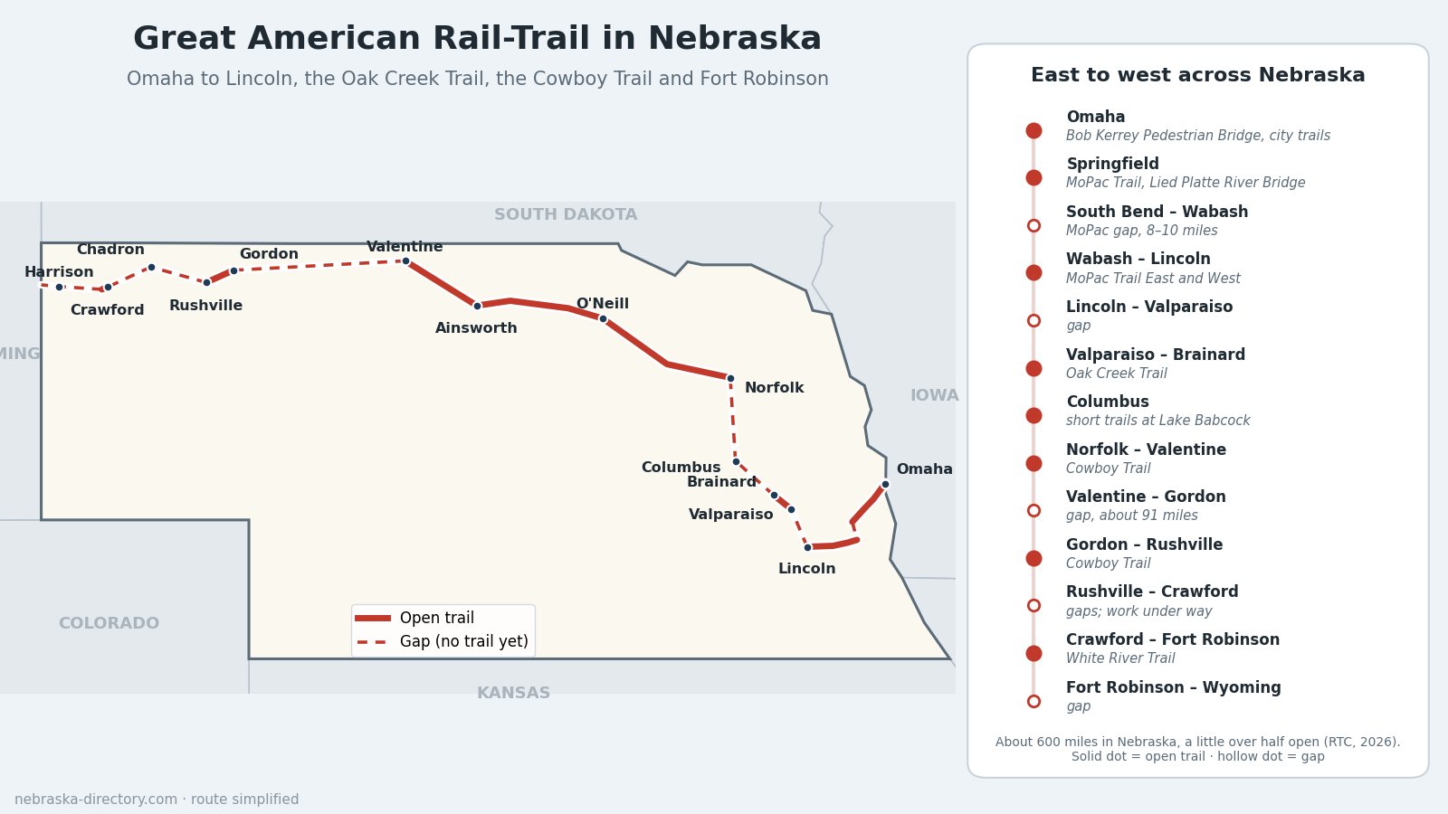
Great American Rail-Trail in Nebraska: Omaha to Fort Robinson
The Great American Rail-Trail is a planned walking and biking route of more than 3,700 miles from Washington, D.C., to Washington State, linking existing rail trails and new connections across 12 states and the District of Columbia. The Rails-to-Trails Conservancy (RTC), which leads the project, reported in June 2026 that about 56% of the route is open. In Nebraska the route runs about 600 miles, from the Missouri River at Omaha through Lincoln, northwest to Columbus and Norfolk, west on the Cowboy Trail across northern Nebraska, and on to Fort Robinson and the Wyoming line. A little over half of the Nebraska route is open trail today; the rest is gaps still being planned and funded.
Note: the route does not follow the Platte River, U.S. 30 or the Union Pacific main line across the state, as some older descriptions suggest. West of Lincoln it heads north to the Cowboy Trail.
Trail status: As of early October 2026, the Lower Platte South Natural Resources District says all NRD-owned trails are closed until further notice. That includes the MoPac Trail East and the Oak Creek Trail on this route. Check lpsnrd.org before you go.
Route at a Glance
- Nebraska length: about 600 miles (RTC gives 601 miles, with 312 miles open and 291 miles of gaps, as of September 2026).
- Enters from: Council Bluffs, Iowa, over the Bob Kerrey Pedestrian Bridge across the Missouri River.
- Leaves to: Wyoming, west of Fort Robinson and Harrison, toward Van Tassell.
- Main trails used: Omaha city trails, the MoPac Trail at Springfield, MoPac Trail East and West into Lincoln, the Oak Creek Trail, trails in Columbus, the Cowboy Trail and the White River Trail.
- Counties on the route: Douglas, Sarpy, Cass, Lancaster, Saunders, Butler, Platte, Madison, Antelope, Holt, Rock, Brown, Cherry, Sheridan, Dawes and Sioux.
The Route, East to West
Omaha and the Missouri River
The route enters Nebraska on the Bob Kerrey Pedestrian Bridge, opened in 2008, which lands next to the Lewis and Clark National Historic Trail Visitor Center at 601 Riverfront Drive. A newer pedestrian bridge north of downtown, nicknamed "Baby Bob" and opened in 2025, links the riverfront into the city. From there a chain of Omaha trails, including the Burt Street, Turner Boulevard, Field Club, South Omaha, Keystone and West Papio trails, carries the route southwest toward Papillion and the 3.3-mile loop around Walnut Creek Lake.
Springfield, the Platte River and the MoPac gap
At Springfield the route picks up the MoPac Trail, about 13 miles on a former Missouri Pacific rail line from Schram Road to the Platte River, which it crosses on the 1,714-foot Lied Platte River Bridge (opened in 2002). Between South Bend and Wabash is the best-known gap on the Nebraska route: 8 to 10 miles with no trail yet.
MoPac Trail East and West into Lincoln
From Wabash, MoPac Trail East runs about 22 miles west through Elmwood and Eagle and past Walton to Lincoln's eastern edge at 98th and A streets. MoPac Trail West continues about 5 to 6 miles into the city, and Lincoln trails including Antelope Valley, the Salt Creek Levee and North 1st Street carry the route through town.
Lincoln to Columbus
Northwest of Lincoln there is a gap to Valparaiso, where the route follows the Oak Creek Trail about 12 miles through Loma to Brainard in the Bohemian Alps. Beyond Brainard the next open pieces are in Columbus: the Robert White and Bob Lake trails at Lake Babcock and the Third Avenue Viaduct Trail.
The Cowboy Trail across northern Nebraska
From Norfolk the route follows the Cowboy Trail, a state rail trail on the former Chicago & North Western line. Nebraska Game and Parks counts about 187 developed miles from Norfolk to Valentine, through Neligh, O'Neill, Atkinson, Bassett, Long Pine and Ainsworth. Highlights include the 595-foot bridge over Long Pine Creek and the quarter-mile bridge 148 feet above the Niobrara River near Valentine. West of Valentine is a gap of about 91 miles to Gordon, then a developed stretch from Gordon to Rushville.
The Pine Ridge and Fort Robinson
Work on the Rushville-to-Chadron section was expected to finish in 2026. From Chadron the planned route continues to Crawford, where the 2.8-mile White River Trail runs to Fort Robinson State Park. West of Fort Robinson, the Friends of the White River Trail own about 34 miles of future trail toward Harrison and the Wyoming line.
Closing the Gaps
The MoPac gap between South Bend and Wabash is RTC's priority project in Nebraska. In April 2022 the Legislature overrode a veto to restore $8.3 million for it, and in November 2024 the Lower Platte South NRD board approved a 10-mile route. In 2025 the Cass County Board rejected the proposed route along 334th Street, and in 2026 lawmakers took back unspent state money, leaving about $1.2 million. The NRD is now studying routes by way of Platte River State Park, Manley, Louisville and the Lied Bridge, and a 2.25-mile extension of MoPac Trail East was due to be finished in fall 2026. Out west, local trail advocates are working on the Pine Ridge sections between Rushville, Chadron and Crawford.
Trailheads and Places Along the Way
- Omaha: Lewis and Clark National Historic Trail Visitor Center, 601 Riverfront Drive, at the west end of the Bob Kerrey bridge
- Springfield: MoPac Trail trailhead at 20105 Nebraska Highway 31, and the Sarpy County Fairgrounds
- Platte River State Park — near the MoPac gap; park entry permit required
- Wabash: MoPac Trail East trailhead on 322nd Street, with gravel parking and a toilet
- Lincoln: MoPac Trail East at 98th and A streets (trailer parking); MoPac Trail West at the Novartis Trailhead, S. 84th St. and Hazelwood Dr., and at Peter Pan Park
- Oak Creek Trail: trailheads in Valparaiso, Loma and Brainard
- Ta-Ha-Zouka Park — Cowboy Trail trailhead in Norfolk
- O'Neill Trailhead – Cowboy Trail — 330 E. Hancock St., O'Neill
- Cowboy Trail — Valentine trailheads at 109 E. 1st St. and 39783 River Drive
- Smith Falls State Park — Nebraska's tallest waterfall, east of Valentine off Highway 12
- Fort Robinson State Park, Fort Robinson History Center and the Trailside Museum — 3200 Highway 20, Crawford; park entry permit required
Related Trails and Corridors
- Cowboy Trail — the longest piece of the route in Nebraska
- Oak Creek Trail — Valparaiso to Brainard
- American Discovery Trail — another coast-to-coast route that also uses the Oak Creek Trail
- Lewis and Clark National Historic Trail — its visitor center sits at the Omaha end of the route
- U.S. 275 corridor and U.S. 20 corridor — the highways that parallel the Cowboy Trail
- ← All Nebraska Trails