
Niobrara National Scenic River: 76 Miles of Spring-Fed Canyon
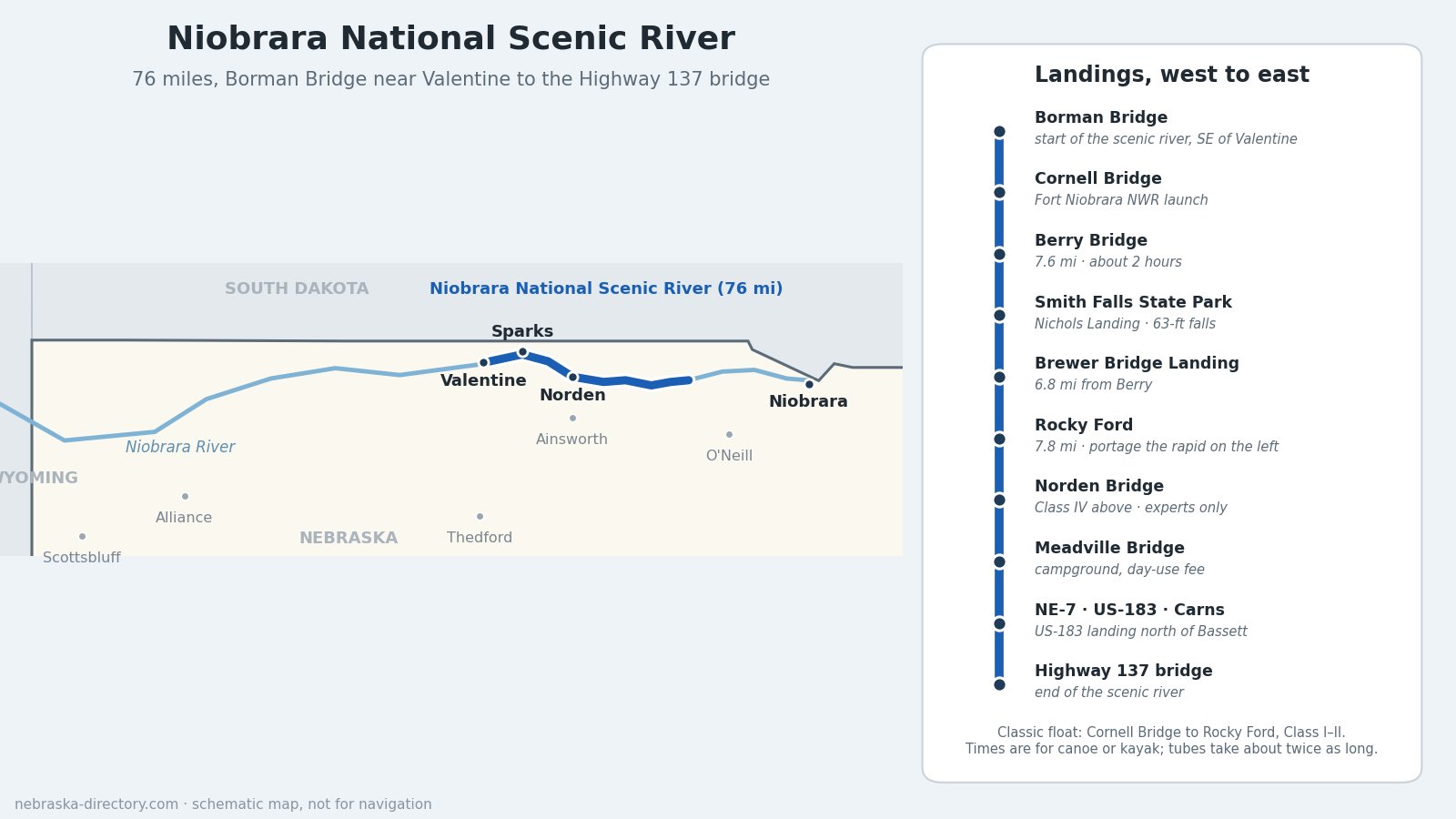
The Niobrara National Scenic River is a 76-mile stretch of the Niobrara River in north-central Nebraska, from Borman Bridge southeast of Valentine downstream to the Nebraska Highway 137 bridge. Congress designated it in 1991. It is the state's best-known float trip: a shallow, clear river below sandstone bluffs, fed mostly by groundwater, with more than 200 waterfalls tumbling down side canyons. Canoes, kayaks, tubes and stock-tank boats share the water from late spring into fall.
Most of the land along the river, including the riverbed, banks, sandbars and islands, is privately owned. Stay on the river and use public landings, campgrounds and outfitters' access points.
River at a Glance
- Length: 76 miles, Borman Bridge to the Highway 137 bridge.
- Designated: Niobrara Scenic River Designation Act, signed May 24, 1991 (Public Law 102-50).
- Counties: Cherry, Brown, Keya Paha and Rock.
- Managed by: the National Park Service, with the U.S. Fish and Wildlife Service inside Fort Niobrara National Wildlife Refuge. The Park Service owns very little land here and works through landowners and the Niobrara Council, formed in 1997 by the four county boards.
- Fees: No National Park Service entrance fee. Some landings, the wildlife refuge and Smith Falls State Park charge their own fees (see below).
- Information: Niobrara National Scenic River headquarters, 214 W. U.S. Highway 20, Valentine; 402-376-1901; nps.gov/niob.
Floating the Niobrara
Most of the scenic river is Class I water, easy for beginners in a canoe, kayak or tube. Summer is the busy season; spring and fall are quieter, and weekdays and Sundays are calmer than Saturdays. The classic float runs from the Fort Niobrara refuge launch at Cornell Bridge down to Rocky Ford.
- Cornell Bridge to Berry Bridge: 7.6 miles, about 2 hours by canoe or kayak.
- Berry Bridge to Brewer Bridge: 6.8 miles, about 1 hour 45 minutes.
- Brewer Bridge to Rocky Ford: 7.8 miles, about 2 hours 30 minutes, with Class II riffles. Portage the Rocky Ford rapid on the left. It can easily flip a boat.
- Below Rocky Ford: the run to Norden Bridge is rated Class IV and is only for experienced paddlers; the Norden Chute must be portaged on the north bank. From Norden down to Highway 137 the river widens and slows.
Times are for canoes and kayaks; tubes take about twice as long. The whole 76 miles can be done in about three days.
Water levels: More than 70% of the river's flow comes from groundwater, so it changes less with rain than most rivers. It is usually lowest from mid-July to mid-September, when a dry year can mean dragging boats across shallows. For the day's flow, call the Park Service at 402-376-1901.
Fees and rules:
- Everyone launching in Fort Niobrara National Wildlife Refuge buys a wristband at the refuge kiosk ($1 per person). No alcohol is allowed in the refuge, and no one may enter the river above Cornell Dam.
- Smith Falls State Park needs a Nebraska park entry permit. Meadville Campground charges a day-use fee.
- Don't bring glass or foam containers. Life jackets are required by state law for boaters under 13. Motorboats and drones are not allowed. Carry out everything you carry in, and camp only in campgrounds.
Outfitters and River Camps
The Park Service lists about a dozen licensed outfitters that rent canoes, kayaks, tubes and tanks and run shuttles. Those in our directory:
- Little Outlaw Canoes, Tubes & Kayaks — Valentine
- Graham Canoe Outfitters — Valentine
- Brewers Canoers & Tubers — Valentine
- Dryland Aquatics — Sparks
- Rock Barn Outfitters — Sparks
- Sunny Brook Camp & Prairie River Outfitter — Sparks
- Rocky Ford Camp & Outfitters — near Valentine
- Fritz’s Island Campground & Tubing — Sparks
- Berry Bridge Resort and its campground — Berry Bridge
- Sparks Store & RV Camp — Sparks
- Niobrara River Ranch — near Valentine
Landings and Bridges, West to East
- Borman Bridge — start of the scenic river, 2.3 miles southeast of Valentine; a 1916 steel truss, next to Borman Bridge Wildlife Management Area. The river is closed to boats a short way below it, inside the refuge.
- Cornell Bridge — the Fort Niobrara refuge launch, where most floats begin. Cornell Dam, just upstream, is dangerous; stay away from it.
- Berry Bridge — a 1921 steel truss, with free public access on the northeast bank.
- Nichols Landing at Smith Falls State Park — about 300 yards from the falls; park entry permit required.
- Brewer Bridge Landing — free, run by the Middle Niobrara Natural Resources District, with parking, water and seasonal restrooms. The old truss beside it is the original 1899 Berry Bridge, moved here in 1921.
- Rocky Ford — end of the classic float; portage trail on the left. The land is private, home to Rocky Ford Camp & Outfitters.
- Norden Bridge — rebuilt in 2016. The take-out is on Nature Conservancy land; private boaters should call the Niobrara Valley Preserve at 402-722-4440 for permission.
- Meadville Bridge — about 14.5 miles north of Ainsworth, with a campground and the Meadville Store.
- Nebraska Highway 7 bridge (signed U.S. 183 until August 2026), on the run down from Meadville, above the mouth of Long Pine Creek.
- U.S. 183 landing north of Bassett — the Park Service's "Highway 7 Landing"; the road between Bassett and Springview was renumbered from Highway 7 to U.S. 183 in August 2026. Fred Thomas Wildlife Management Area, across the river, allows primitive camping.
- Carns Bridge — the 1913 state-aid bridge, about halfway to Highway 137; a new bridge was built beside it in 2025–26. No river access.
- Highway 137 Landing — end of the scenic river, on the left, upstream side. It was damaged in the 2019 flood; call the Park Service before planning to take out here.
- Public canoe and kayak access point — listed near Springview.
Places Along the River
- Fort Niobrara National Wildlife Refuge — 19,131 acres, 5 miles east of Valentine on Highway 12. Set aside in 1912, it keeps a bison herd of about 350; part of it became Nebraska's first designated wilderness in 1976. The 0.84-mile Fort Falls Trail leads to a 45-foot waterfall. Office open weekdays 8 to 4; 402-376-3789. The Fort Niobrara Post Cemetery is nearby.
- Smith Falls State Park — home of Smith Falls, at 63 feet the tallest waterfall in Nebraska. Visitors cross the river on the footbridge, a 1910 truss bridge moved here from Verdigre in 1996. Camping, a visitor center (early May to September) and a park entry permit; about 3 miles southwest of Sparks.
- Niobrara Valley Preserve — The Nature Conservancy's 56,000-acre working ranch, including 25 miles of river, with two bison herds and hiking trails. No camping or campfires.
- Tunnel Rock — a white chalk rock formation with a natural opening, in the canyon between Sparks and Norden.
- The Cowboy Trail bridge at Valentine — a former Chicago & North Western railroad bridge built in 1910, a quarter-mile long and 148 feet above the river, now part of the Cowboy Trail.
- Cherry County Historical Society Museum — Valentine.
A Biological Crossroads
Six kinds of plant communities meet in the Niobrara valley: northern boreal forest, western pine forest, eastern hardwood forest, tallgrass prairie, mixed-grass prairie and Sandhills prairie. Groundwater seeping from the canyon walls feeds more than 200 waterfalls and cool side canyons, where small groves of paper birch, left behind since the last ice age, still grow far south of their usual range. River otters, bison, elk, wild turkeys, great blue herons and least terns all live along the river.
History
The name comes from the Ponca words for "running water" or "spreading water." In the early 1700s the Ponca built earth-lodge villages near the river's mouth; the Lakota hunted the Sandhills to the west, and the 1868 treaty placed much of the Niobrara country in the Great Sioux Reservation. Trader James MacKay crossed the region in 1795–96 and called the Sandhills a "grand desert of moving sand."
The Army chose the site of Fort Niobrara east of present-day Valentine in 1879, and the post opened in 1880 to watch over the nearby Rosebud reservation. Its troops included the 9th Cavalry, and John J. Pershing served there. The fort closed in 1906, and its land became Fort Niobrara National Wildlife Refuge in 1912. The railroad reached Valentine in 1883, and ranches spread across the Sandhills, helped by the 1904 Kincaid Act's 640-acre homesteads.
In the 1970s the federal O'Neill Unit irrigation project proposed a dam on the river near Norden. Landowners and conservationists formed the Save the Niobrara River Association in 1975 and went to court against the Norden Dam. Their effort, and the request of river landowners for federal protection, led to the 1991 act that made this stretch a national scenic river.
Down to the Missouri
Below Highway 137 the Niobrara continues east past Spencer and Lynch to meet the Missouri River at Niobrara. The last 20 miles are part of the Missouri National Recreational River. At the mouth, Niobrara State Park has cabins, trails and a view of both rivers, and Pretty Feather Canoe Rental serves the lower river. The Ponca Trail of Tears began near here in 1877.
Plan Your Trip
- Towns near the river: Valentine, Sparks, Norden, Johnstown, Ainsworth, Springview, Bassett and Wood Lake.
- Safety: The river is shallow and rocky in places. If you tip over, stay on the upstream side of your boat. Watch for poison ivy, ticks and rattlesnakes on shore, and expect weak cell service in the canyon. Climbing the cliffs is trespassing and dangerous.
- Weather and roads: Nebraska road and weather cameras; summer highs run from the 80s to the low 100s, with afternoon thunderstorms.
- Visitor center: call 402-376-1901 for current hours before you go.
Related Trails and Corridors
- Cowboy Trail — crosses the Niobrara at Valentine on the high railroad bridge
- US Highway 20 — the main east–west road through Valentine and Ainsworth
- Nebraska Highway 12 — the northern route east from Valentine toward Niobrara
- US Highway 183 — crosses the scenic river north of Bassett (the former Highway 7 bridge)
- Ponca Trail of Tears
- ← All Nebraska Trails