
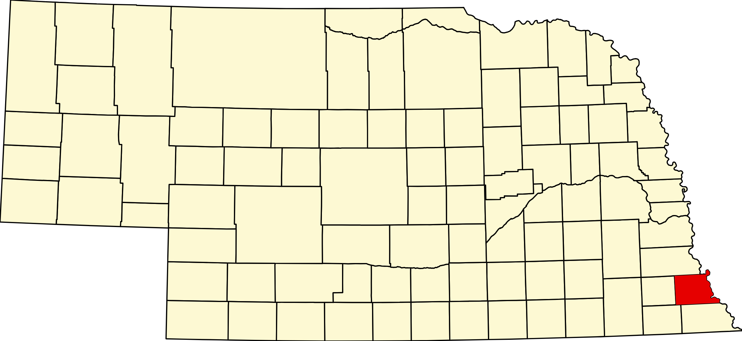
Nemaha County, Nebraska
County seat: Auburn · Created: 1854 as Forney County; renamed Nemaha by the first Territorial Legislature in March 1855 · Named for: the Nemaha River, from an Otoe word for muddy water · License plates: prefix 44 · Population: 7,074 (2020 census) · Area: 407 sq mi of land
About Nemaha County
Nemaha County lies on the Missouri River in the southeastern corner of Nebraska, crossed by the Little Nemaha River. Its southeastern part was the Nemaha Half-Breed Reservation, set aside by an 1830 treaty, where St. Deroin became the county's first town in 1853–54. It began as Forney County, named for John W. Forney, and took the name Nemaha in 1855, with Brownville as county seat. Brownville grew into one of the largest towns in the territory, with the first telegraph into Nebraska (1860) and the U.S. Land Office, and Peru gained the state's first state-supported college in 1867.
The railroads remade the map. The Missouri Pacific and the Burlington founded or moved Auburn, Brock, Johnson, Julian, Howe and Glenrock in 1879–82, while the river towns of Aspinwall and St. Deroin faded. Sheridan and Calvert merged as Auburn in 1882 and took the county seat in 1883. The county counted 14,952 people in 1900. Cooper Nuclear Station near Brownville has produced power since 1974.
Towns of Nemaha County
Cities and villages
Auburn
The Nemaha County seat, a city of 3,470 where US 75 crosses US 136, formed in 1882 when the rival towns of Sheridan and Calvert merged. The 1900 courthouse, Legion Memorial Park, the Nemaha Valley Museum and the county fair in August.
Peru
City of 648 on the Missouri River bluffs, home of Peru State College, Nebraska's first state-supported college (1867). The Steamboat Trace trail, Peru Bottoms WMA and Old Man River Days in June.
Brownville
Historic Missouri River village of 139, founded in 1854 and the first county seat, with the whole old town on the National Register. Museums, the Village Theatre, a concert series, a winery and the 1939 bridge to Missouri.
Johnson
Village of 309 just off NE 105 and US 136, laid out in 1869 by Julius A. Johnson and moved to the Burlington line in 1881–82. Home of Johnson-Brock schools and the Father's Day Chicken BBQ since 1965.
Brock
Village of 123 on NE 67 by the Little Nemaha River, laid out in 1854 as Dayton and called Howard, Clinton and Podunk before the Missouri Pacific renamed it Brock in 1882.
Nemaha
Village of 114 on NE 67 south of Brownville, laid out in 1854 as Nemaha City and reached by the Burlington in 1879. Near Cooper Nuclear Station, the Aspinwall site and Indian Cave State Park.
Julian
Village of 46 just west of US 75, a French settlement named for Julian Bahuaud, with a Missouri Pacific station and St. Bernard Catholic Church, founded in 1881.
Former towns and post office communities
Howe
Missouri Pacific station south of Auburn, platted in 1882 as Bedford and named Howe for Church Howe. Post office 1882–1962; the Bedford Cemetery remains.
Glenrock
Little Nemaha River settlement with a post office from 1859 and a Missouri Pacific station of 1882 that shipped ice and quarried stone. Its cemetery remains.
St. Deroin
The county's first town, a trading post of 1853–54 on the Nemaha Half-Breed Reservation, named for Joseph Deroin. Its 1868 school, rebuilt store and cabin stand in Indian Cave State Park, with living-history weekends.
Aspinwall
Missouri River steamboat landing on the Half-Breed Tract, settled in 1853 and booming to about 500 people in 1864. Passed over by the railroad, it was gone by about 1918.
Travel Corridors
US 75 — north–south through Auburn, from Nebraska City and Julian to Howe and Falls City. US 75 Corridor →
US 136 — the Heritage Highway, east–west from Tecumseh past Johnson to Auburn and Brownville, crossing the Missouri on the 1939 Brownville Bridge. US 136 Corridor →
State highways — NE 67 runs from Talmage past Brock to US 75, then to Peru, Brownville and Nemaha and south to Shubert, with spur S-64E to Indian Cave State Park; NE 105 runs past Johnson and ends at NE 67 near Brock.
Cameras: View Nemaha County cameras → · Road conditions: Nebraska 511
Things to See
In Brownville: the historic district and its museums, including the Bailey House, the depot and the dredge Captain Meriwether Lewis, the Village Theatre, the Concert Series, the Flatwater Folk Art Museum, Whiskey Run Creek Winery and the Brownville Bridge. In Auburn: the 1900 courthouse, the Nemaha Valley Museum and Legion Memorial Park. In Peru: Peru State College. At St. Deroin: the restored school in Indian Cave State Park.
Outdoors
Indian Cave State Park on the Missouri bluffs has petroglyphs, about 38 miles of trails and two campgrounds. The Steamboat Trace trail follows the old railroad from near Nebraska City through Peru toward Brownville. Peru Bottoms WMA and Aspinwall Bend WMA are open for hunting, and the Nemaha NRD's Duck Creek Recreation Area near Peru has a lake and campground. Campers can also use Brownville Riverside Park and the Auburn RV Park.
Nemaha County Business Directory
Businesses within 20 miles of: Auburn · Peru · Brownville · Johnson · Brock · All listings →
Adjacent Counties
Otoe County (north) · Atchison County, Missouri (east, across the Missouri) · Holt County, Missouri (southeast, across the Missouri) · Richardson County (south) · Pawnee County (southwest) · Johnson County (west)
Events
2026 dates: the Brownville Flea Market (May 23–25 and September 26–27); Old Man River Days in Peru (June 5–7); the Brownville Village Theatre summer season (from June 5); Johnson's Father's Day Chicken BBQ (June); the Nemaha County Fair in Auburn (August 9–12); the Brownville Concert Series (monthly, April–December); and Haunted Hollow at Indian Cave State Park (October 9–10, 17 and 24).
Events in Nemaha County
- Brownville Flea Market (Brownville)
- Johnson Father’s Day Chicken BBQ (Johnson)
Johnson Father's Day Chicken BBQ is held in Johnson, Nebraska, on Father's Day weekend. - Nemaha County Fair (Auburn)
The Nemaha County Fair is Auburn’s annual county fair, held each August and organized by the Nemaha County Agricultural Society. - Old Man River Days (Peru)
Old Man River Days is held in Peru, Nebraska, on the first weekend of June.
Know of another event in the county? Tell us about it.
Nemaha County at a Glance
Nemaha County, Nebraska — on the Missouri River in the state's southeastern corner. County seat Auburn; the other city is Peru.
Getting there: US 75 from Nebraska City and Falls City, US 136 from Tecumseh and across the Brownville Bridge from Missouri.
For visitors: historic Brownville, Peru State College, Indian Cave State Park and St. Deroin, the Steamboat Trace trail and the Nemaha County Fair in Auburn. Hospital: Nemaha County Hospital in Auburn.
Vehicles registered in Nemaha County carry license plate number 44. See what every Nebraska county number means.
Nemaha County Businesses & Places
154 listings in Nemaha County.
Click a category to see the businesses.
Eat & Drink (3)
- Lyceum — Restaurant, Brownville
- Subway – 2322 Dahlke Ave, Auburn — Subway, Auburn
- Whiskey Run Creek Vineyard & Winery — Winery & Vineyard, Brownville
Stay (1)
- Auburn Inn Motel — Hotel, Auburn
Outdoors & Recreation (10)
- Aspinwall Bend WMA — Public Hunting Areas & WMAs, Nebraska
- Auburn Country Club — Golf Course, Auburn
- Auburn RV Park & Campground — Campgrounds & RV Parks, Auburn
- Brownville Riverside Park and Landing — Campgrounds & RV Parks, Brownville
- Duck Creek Recreation Area (Nemaha NRD) — Campgrounds & RV Parks, Nebraska
- Long's Creek RV Park — Campgrounds & RV Parks, Auburn
- Peru Boat Ramp — Public Hunting Areas & WMAs, Nebraska
- Peru Bottoms WMA — Public Hunting Areas & WMAs, Nebraska
- Southside RV Park — Campgrounds & RV Parks, Auburn
- Steamboat Trace Trail — Trails & Rail Trails, Nebraska
Places to Visit (12)
- Brownville Bridge — Bridge, Brownville
- Brownville Concert Series — Arts Center, Brownville
- Brownville Depot and Railroad History Museum — History & Heritage Museums, Brownville
- Brownville Fine Arts Association — Art Museums, Brownville
- Brownville Historical Society Museum at Bailey House — History & Heritage Museums, Brownville
- Brownville Village Theatre — Arts Center, Brownville
- Flatwater Folk Art Museum — Art Museums, Brownville
- Governor Furnas House Museum — Specialty Museums, Brownville
- Legion Memorial Park — City Parks, Auburn
- Meriwether Lewis Dredge and Missouri River History Museum — History & Heritage Museums, Brownville
- Nemaha Valley Museum — Specialty Museums, Auburn
- Sage Memorial Museum — Specialty Museums, Brownville
Events & Venues (6)
- Auburn Municipal Pool — Swimming Pool, Auburn
- Brownville Flea Market — Local Celebration, Brownville
- Johnson Father's Day Chicken BBQ — Festivals & Celebrations, Johnson
- Nemaha County Fair — County Fair, Auburn
- Nemaha County Fairgrounds — Fairground, Auburn
- Old Man River Days — Festivals & Celebrations, Nebraska
Health & Emergency (2)
- Miracle-Ear Hearing Aid Center Auburn — Hearing Aids, Auburn
- Nemaha County Hospital — Hospital, Auburn
Community & Faith (54)
- Amateur Radio Repeaters - Nemaha County (via RepeaterBook.com) — Amateur Radio Repeater, Nebraska
- Aspinwall Cemetery — Auburn — Cemeteries, Aspinwall
- Auburn, First Presbyterian Church — Presbyterian Church, Auburn
- Auburn, NE First UMC — Methodist Church, Auburn
- Bedford Cemetery — Howe — Cemeteries, Howe
- Brock UMC — Methodist Church, Brock
- Brownville UMC — Methodist Church, Brownville
- Calvary Christian Center Assembly of God — Pentecostal, Auburn
- Clifton Cemetery — Johnson — Cemeteries, Johnson
- Coryell Park and Mausoleum — Cemeteries, Brock
- Glenrock Cemetery — Auburn — Cemeteries, Glenrock
- Grant Evergreen Cemetery — Auburn — Cemeteries, Auburn
- Highland Baptist Cemetery — Auburn — Cemeteries, Auburn
- Highland Cemetery — Peru — Cemeteries, Nebraska
- Highland Methodist Cemetery — Auburn — Cemeteries, Auburn
- Highland Ridge Cemetery — Peru — Cemeteries, Nebraska
- Hillsdale Cemetery — Auburn — Cemeteries, Auburn
- Holy Cross Cemetery — Auburn — Cemeteries, Auburn
- Honey Creek Cemetery — Brownville — Cemeteries, Brownville
- Howell Cemetery — Auburn — Cemeteries, Auburn
- Johnson Cemetery — Johnson — Cemeteries, Johnson
- Johnson, NE UMC — Methodist Church, Johnson
- Karn Cemetery — Auburn — Cemeteries, Auburn
- Kite Cemetery — Auburn — Cemeteries, Auburn
- Lafayette Cemetery — Brock — Cemeteries, Brock
- Linden Cemetery — Auburn — Cemeteries, Auburn
- London Cemetery — Auburn — Cemeteries, Auburn
- Martin Luther Church Cemetery — Auburn — Cemeteries, Auburn
- Mount Vernon Cemetery — Peru — Cemeteries, Nebraska
- Mount Zion Cemetery — Nemaha — Cemeteries, Nebraska
- Nemaha Cemetery — Nemaha — Cemeteries, Nebraska
- Nemaha UMC — Methodist Church, Nebraska
- Pleasant View Cemetery — Auburn — Cemeteries, Auburn
- Saint Bernards Church Cemetery — Julian — Cemeteries, Julian
- Saint Frederick Cemetery — Johnson — Cemeteries, Johnson
- Saint James Lutheran Cemetery — Auburn — Cemeteries, Auburn
- Saint Johns Lutheran Cemetery — Auburn — Cemeteries, Auburn
- Saint Matthews Lutheran Cemetery — Johnson — Cemeteries, Johnson
- Saint Paul Lutheran Cemetery — Auburn — Cemeteries, Auburn
- Sheridan Cemetery — Auburn — Cemeteries, Auburn
- Sheridan West Memorial Cemetery — Auburn — Cemeteries, Auburn
- South Auburn Church of Christ — Other Denomination, Auburn
- St. Bernard Catholic Church Julian — Catholic Church, Julian
- St. Clara Peru — Catholic Church, Nebraska
- St. Deroin Cemetery — Cemeteries, Nebraska
- St. Joseph Catholic Church Auburn — Catholic Church, Auburn
- St. Matthew Lutheran Church — Lutheran Church, Johnson
- St. Paul Lutheran Church — Lutheran Church, Auburn
- St. Paul Lutheran Church (Hickory Grove) — Lutheran Church, Auburn
- Stone Church Cemetery — Auburn — Cemeteries, Auburn
- Trinity Lutheran Cemetery — Auburn — Cemeteries, Auburn
- Trinity Lutheran Church — Lutheran Church, Auburn
- Walnut Grove Cemetery — Brownville — Cemeteries, Brownville
- Zion Lutheran Church Cemetery — Auburn — Cemeteries, Auburn
Government & Resources (28)
- Auburn Chamber of Commerce — Chamber of Commerce, Auburn
- Auburn City Hall — City Hall, Auburn
- Auburn Housing Authority — Housing Authority, Auburn
- Auburn Memorial Library — Libraries, Auburn
- Auburn Police Department — Police Station, Auburn
- Auburn Post Office — Post Office, Auburn
- Auburn Senior Center — Senior Citizen Center, Auburn
- Auburn USDA Service Center — USDA Service Center (FSA/NRCS), Auburn
- Brock Village Office — City Hall, Brock
- Brownville Village Office — City Hall, Brownville
- Johnson Community Center & Library — Libraries, Johnson
- Johnson Post Office — Post Office, Johnson
- Johnson Village Office — City Hall, Johnson
- Julian Village Office — City Hall, Julian
- Nemaha County Assessor — County Assessor, Auburn
- Nemaha County Attorney's Office — County Attorney, Auburn
- Nemaha County Clerk — County Clerk, Auburn
- Nemaha County Court — County Court, Auburn
- Nemaha County Courthouse — Court House, Auburn
- Nemaha County Emergency Management — Emergency Management, Auburn
- Nemaha County Sheriff — County Sheriff, Auburn
- Nemaha County Treasurer — County Treasurer, Auburn
- Nemaha County Veterans Service Office — Veterans Office, Auburn
- Nemaha County Weed Superintendent — County Weed Control, Auburn
- Nemaha Village Office — City Hall, Nebraska
- Peru Chamber of Commerce — Chamber of Commerce, Nebraska
- Peru City Hall — City Hall, Nebraska
- Southeast District Health Department — County/District Health Department, Auburn
Education (12)
- Auburn High School — High School, Auburn
- Auburn Middle School — Elementary & Middle School, Auburn
- Auburn Public Schools — School District (K-12 / General), Auburn
- Calvert Elementary — Elementary & Middle School, Auburn
- Educational Service Unit 4 — Educational Service Unit, Auburn
- Elementary School at Johnson — Elementary & Middle School, Johnson
- High School at Johnson — High School, Johnson
- Johnson - Brock Junior High School — High School, Johnson
- Johnson-Brock Public Schools — School District (K-12 / General), Johnson
- Little Learners Preschool — Elementary & Middle School, Auburn
- Nemaha County Extension — County Extension Office, Auburn
- Peru State College — 4-Year College / University, Nebraska
Utilities (9)
- Auburn Municipal Utilities — Electric Power Provider, Auburn
- City of Auburn — Water Utility / District, Auburn
- Nemaha County RWD #2 — Water Utility / District, Johnson
- Nemaha County RWD 1 — Water Utility / District, Auburn
- Village of Brock — Water Utility / District, Brock
- Village of Brownville — Water Utility / District, Brownville
- Village of Johnson — Water Utility / District, Johnson
- Village of Julian — Water Utility / District, Julian
- Village of Nemaha — Water Utility / District, Auburn
Automotive (5)
- Auburn Auto Center — Auto Repair, Auburn
- Casey's General Store - Auburn — Casey's, Auburn
- Casey's General Store - Peru — Casey's, Nebraska
- Gilbert Services — Auto Repair, Auburn
- Meyer-Earp Auto Center — Franchised New Car Dealer, Auburn
Agriculture & Farm (4)
- AKRS Equipment Solutions - Auburn — Equipment Dealers, Auburn
- Clark Grain Company — Grain Elevator / Cooperative, Johnson
- Cornhusker Beef Company LLC — Custom Meat Locker / Processing, Johnson
- Jarrett Oestmann - Farrier — Farrier, Auburn
Professional Services (3)
- Auburn Agency — Insurance, Auburn
- Auburn Insurance Service — Insurance, Auburn
- Nebraska Title Company - Auburn — Auburn
Transportation (3)
- Blue Rivers Area Agency on Aging - Auburn — Public Transportation, Auburn
- Blue Rivers Transportation System (Auburn) — Public Transportation, Auburn
- Farington Field Airport (K01) — Municipal / General Aviation Airport, Auburn
Media (2)
- Nemaha County Herald — News Paper, Auburn
- Peru Times — News Paper, Nebraska