
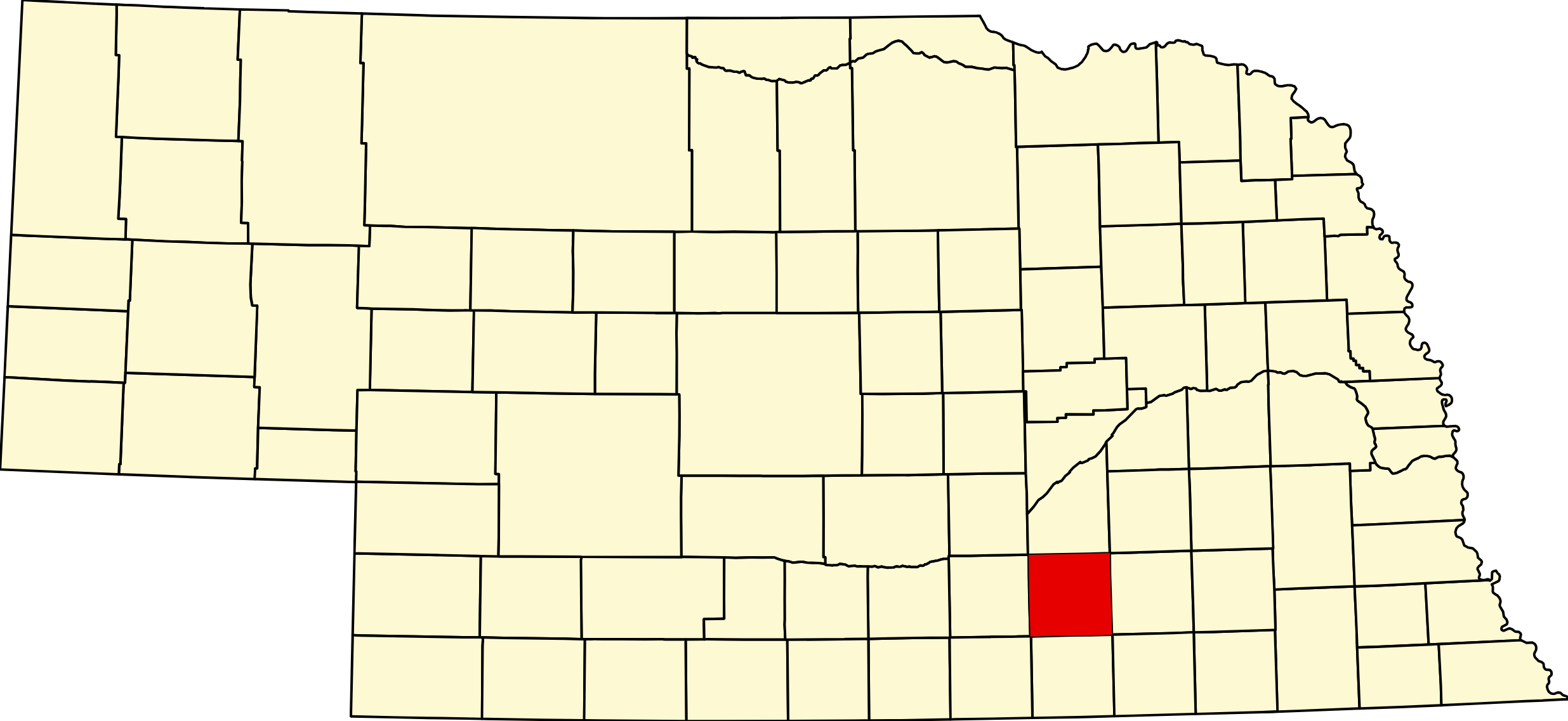
Clay County, Nebraska
Clay County is a south-central Nebraska county covering 572 square miles of fertile agricultural land. The county seat is Clay Center, situated at the junction of U.S. Highway 6 and Nebraska Highway 14. Clay County's economy is anchored by corn, soybean, and cattle production across the Republican River watershed. The county was organized in 1871 and named for Kentucky statesman Henry Clay.
Clay County is home to 13 communities and approximately 6,000 residents. It borders Hamilton County (north), Fillmore County (east), Nuckolls County (south), and Adams County (west). Notable Clay County figures include Baseball Hall of Fame manager Billy Southworth, arctic explorer Walter Wellman, Medal of Honor recipient Jacob Volz, and Governor Samuel McKelvie.
Towns in Clay County
Browse all towns: Clay County Town Index →
Clay Center, Nebraska (68933)
County seat at the junction of US-6 and NE-14. Founded 1879, named for Henry Clay. Clay Center High School consistently ranks above state academic averages.
Pop: ~735 | Highways: US-6, NE-14 | City, County Seat
Sutton, Nebraska (68979)
Clay County's largest city, founded 1871 on the Burlington railroad and named for Sutton, Massachusetts. Birthplace of Medal of Honor recipient Jacob Volz and arctic explorer Walter Wellman.
Pop: ~1,447 | Highways: US-6 | City
Harvard, Nebraska (68944)
Founded 1871, named after Harvard University. Birthplace of Baseball Hall of Famer Billy Southworth and musician Paul Revere (Paul Revere and the Raiders).
Pop: ~951 | City
Edgar, Nebraska (68935)
City in southern Clay County, platted 1873. Named for the son of a pioneer settler.
Pop: ~428 | City
Fairfield, Nebraska (68938)
Founded 1872. Birthplace of Governor Samuel Roy McKelvie (19th Governor of Nebraska). Sandy Creek Jr/Sr. High School serves the area.
Pop: ~330 | City
Glenvil, Nebraska (68941)
Village founded 1873. The 1903 Glenville School is on the National Register of Historic Places. In 1997, Bill Gates donated $5,000 for a community playground after residents wrote celebrity letters.
Pop: ~267 | Village
More Clay County Communities
Trumbull (68980) · Deweese (68934) · Saronville (68975) · Ong (68452) · Inland (68954) · Verona · Eldorado
Clay County Cameras
Highways & Corridors
U.S. Highway 6 runs east-west through Clay Center and Sutton, connecting Clay County to Hastings (Adams County, west) and York (east).
Nebraska Highway 14 runs north-south through Clay Center, linking Hamilton County (north) to Nuckolls County (south).
Browse all Nebraska Corridors →
Clay County Directory
Region
Clay County is part of South Central Nebraska — a region of agricultural communities across the Republican River watershed.
Adjacent Counties
Hamilton County (north, #28) · Fillmore County (east, #34) · Nuckolls County (south, #42) · Adams County (west, #14)
County Seat: Clay Center
Founded: Boundaries set February 16, 1867; organized September 11, 1871
Named For: Henry Clay, the Kentucky statesman
License Plate Prefix: 30
Population: 6,104 (2020 census)
Area: 574 sq mi
History
Nebraska has had two Clay Counties, and the present one is not continuous with the first. The original was created in 1855 and later absorbed; the modern county was organized in 1871. Clay Center is the county seat and its name, like Center in Knox County, is its explanation — it sits in the middle.
Sutton was the first town, settled in 1870 by families from Sutton, Massachusetts, and the Burlington and Missouri River Railroad brought Harvard, Edgar, Fairfield, Glenvil, Ong, Trumbull, Saronville and Deweese through the 1870s and 1880s. It has been a farming county throughout.
Geography
Clay County covers about 573 square miles of south-central Nebraska, on the level loess plain between the Platte and the Little Blue. Its defining feature is not a river but a scatter of shallow wetlands: this is the heart of the Rainwater Basin, a landscape of clay-bottomed playas that hold snowmelt in spring and often dry out by late summer.
School Creek and the West Fork of the Big Blue drain the county, and the Little Blue clips the far south. It borders Hamilton County to the north, York County to the north-east, Fillmore County to the east, Nuckolls County to the south, Webster County to the south-west and Adams County to the west.
Outdoors — Camping, RV, Hunting & Fishing
Clay County is a hunting and birding county, not a camping or fishing county, and it is worth saying so plainly. What it has instead is one of the great wildlife spectacles in North America.
The Rainwater Basin
Each spring an estimated seven to nine million ducks and two to three million geese stop in the Rainwater Basin. Clay County holds sixteen federal Waterfowl Production Areas totalling about 6,374 acres — the largest concentration of any county in the district.
An important distinction: Harvard Marsh, Massie Lagoon and Smith Lagoon are federal Waterfowl Production Areas owned by the U.S. Fish and Wildlife Service, not Nebraska state Wildlife Management Areas. That is why they do not appear on Game and Parks’ WMA list. All are open to public hunting.
Harvard WPA is the flagship — two miles west of Harvard, about 1,485 acres, of which 760 are wetland. Up to half a million waterfowl in mid-March, plus sandhill cranes, bald eagles and greater prairie-chickens. Facilities are parking areas and nothing else — no trails, no restrooms, no water, no camping. Free.
Check conditions before traveling. These are playas: in a dry year they can be bone dry and empty of birds, and the section roads can be impassable when wet. The Rainwater Basin district office at Funk is on (308) 263-3000.
Camping and RV
Sutton RV Park and Campground, 107 West Grove Street, is the only campground confirmed in the county. Sites 1–14 are premium, with 20/30/50-amp electric plus water and sewer at the site, at $10 a night or $300 a month. Sites A, B and C are basic, 20/30-amp electric and water only, at $5 a night for up to fourteen days. Check in at City Hall; after hours contact the police department. Showers, restrooms and a separate dump station are not confirmed.
There is no state park, state recreation area or NRD campground anywhere in Clay County. Nearest full-service public camping is Hastings, about eighteen miles west in Adams County.
Fishing
Honestly: there is no meaningful public fishery in Clay County. The Rainwater Basin wetlands are shallow, ephemeral playas — waterfowl habitat, not fish habitat. Game and Parks lists no managed fishing lake in the county, and no developed public access on the Little Blue or School Creek.
Hunting
Waterfowl first — mallard, pintail, blue-winged and green-winged teal, white-fronted and light geese — with pheasant and quail on the upland margins and whitetail on the larger tracts. The late-winter Light Goose Conservation Order is a significant draw. A federal duck stamp is needed alongside Nebraska permits and HIP registration, and non-toxic shot is required.
Kissinger Basin WMA, about 486 acres near Fairfield, is the state WMA in the county. Open Fields and Waters walk-in tracts change annually — use the current Public Access Atlas.
Trails
There is no rail-trail, state trail or scenic byway in Clay County. The county’s outdoor draw is the spring migration, watched from county roads and WPA parking areas.
Events
The Clay County Fair at Clay Center anchors the summer, and Sutton, Harvard, Edgar and Fairfield each hold their own celebrations. For birders the fixed point of the year is the spring waterfowl migration in March.
Dates move year to year, so they are kept with the listings rather than repeated here.
Browse event listings in Clay County →
Submit an event or correction →
Clay County at a Glance
Clay County, Nebraska — about 573 square miles of level loess farmland in the south-central part of the state, and the heart of the Rainwater Basin. County seat Clay Center. 216 listings across 13 towns.
Getting there: US-6 crosses the north through Sutton and Harvard; NE-14 and NE-41 cross the county; I-80 lies about fifteen miles north.
For visitors: the spring waterfowl migration — seven to nine million ducks and up to three million geese pass through the Rainwater Basin, with up to half a million on Harvard Marsh alone in mid-March. Sixteen federal Waterfowl Production Areas, all open to public hunting. Note there is no public fishing lake and only one campground, at Sutton.
Vehicles registered in Clay County carry license plate number 30. See what every Nebraska county number means.
Clay County Businesses & Places
216 listings in Clay County.
Click a category to see the businesses.
Eat & Drink (7)
- Legacy Bar - Harvard — Bar & Grill, Harvard
- Maury's Place — Bar & Grill, Nebraska
- Subway – 107 E Hwy 6, Sutton — Subway, Nebraska
- Sutton Bakery — Bakery, Nebraska
- Sutton Leigon — American Restaurant, Nebraska
- The End Zone — Bar & Grill, Edgar
- The Mustang Restaurant and Lounge — Bar & Grill, Nebraska
Stay (2)
- Edgar Hotel — Hotel, Edgar
- Fox Hollow Motel — Motel, Nebraska
Outdoors & Recreation (9)
- Bluewing WMA — Public Hunting Areas & WMAs, Nebraska
- Bulrush WMA — Public Hunting Areas & WMAs, Nebraska
- City of Edgar Camping Facility — Campgrounds & RV Parks, Edgar
- Fox Hollow Golf Course — Golf Course, Nebraska
- Green Wing WMA — Public Hunting Areas & WMAs, Nebraska
- Greenhead WMA — Public Hunting Areas & WMAs, Nebraska
- Kissinger Basin WMA — Public Hunting Areas & WMAs, Nebraska
- Sutton RV Park and Campground — Campgrounds & RV Parks, Nebraska
- White Front WMA — Public Hunting Areas & WMAs, Nebraska
Places to Visit (3)
- Clay County Museum — History & Heritage Museums, Clay Center
- Sutton Historical Society Museum — Museum, Nebraska
- Sutton Nebraska Museum — Specialty Museums, Nebraska
Events & Venues (2)
- Clay County Fairgrounds — County Fair, Clay Center
- Regal Lanes — Bowling Alley, Edgar
Health & Emergency (9)
- Barbee Veterinary Clinic — Mixed / General Practice, Nebraska
- Brodstone Memorial Hospital dba Brodstone Family Medical Center - Edg — Medical Clinic, Edgar
- Harvard Community Medical Clinic — Medical Clinic, Harvard
- Henderson Health Care Services, Inc. — Medical Clinic, Nebraska
- South Central Chiropractic — Chiropractor, Nebraska
- Sutton Family Practice — Medical Clinic, Nebraska
- Sutton Pharmacy — Pharmacy, Nebraska
- Sutton Veterinary Clinic PC — Mixed / General Practice, Nebraska
- Sutton Vision Center — Optometrist, Nebraska
Travel Services (1)
- Sutton Area Chamber of Commerce — Nebraska
Shopping & Gifts (6)
- Chris's Creations — Arts & Crafts, Harvard
- Corner Market — Grocery, Edgar
- Eagle Eye Collectibles — Antique Mall, Edgar
- Harvard Foodmart & Liquor — Grocery, Harvard
- Rock On — Boutique, Harvard
- Sugar Shack General Store — General Store, Edgar
Government & Resources (54)
- Brumbaugh Public Library - Glenvil — Libraries, Glenvil
- Clay Center American Legion 109 N Alexander — Senior Citizen Center, Clay Center
- Clay Center City Hall — City Hall, Clay Center
- Clay Center Housing Authority — Housing Authority, Clay Center
- Clay Center Police Department — Police Station, Clay Center
- Clay Center Post Office — Post Office, Clay Center
- Clay Center Public Library — Libraries, Clay Center
- Clay Center USDA Service Center — USDA Service Center (FSA/NRCS), Clay Center
- Clay County Assessor — County Assessor, Clay Center
- Clay County Attorney's Office — County Attorney, Clay Center
- Clay County Clerk — County Clerk, Clay Center
- Clay County Court — County Court, Clay Center
- Clay County Courthouse — Court House, Clay Center
- Clay County Driver License Office — County Driver License, Clay Center
- Clay County Emergency Management — Emergency Management, Clay Center
- Clay County Senior Center — Senior Citizen Center, Clay Center
- Clay County Sheriff — County Sheriff, Clay Center
- Clay County Treasurer — County Treasurer, Clay Center
- Clay County Veterans Service Office — Veterans Office, Clay Center
- Clay County Weed Superintendent — County Weed Control, Clay Center
- Community Center - Edgar — Senior Citizen Center, Edgar
- Deweese Village Office — City Hall, Deweese
- Edgar City Hall — City Hall, Edgar
- Edgar Housing Authority — Housing Authority, Edgar
- Edgar Police Department — Police Station, Edgar
- Edgar Post Office — Post Office, Edgar
- Fairfield City Hall — City Hall, Fairfield
- Fairfield Community Food Pantry — Food Pantry, Fairfield
- Fairfield Fire Department — Fire Station, Fairfield
- Fairfield Post Office — Post Office, Fairfield
- Fairfield Public Library — Libraries, Fairfield
- Glenvil Fire Department — Fire Station, Glenvil
- Glenvil Police Department — Police Station, Glenvil
- Glenvil Post Office — Post Office, Glenvil
- Glenvil Village Office — City Hall, Glenvil
- Harvard City Hall — City Hall, Harvard
- Harvard Fire Department — Fire Station, Harvard
- Harvard House Assisted Living — Assisted Living, Harvard
- Harvard Housing Authority — Housing Authority, Harvard
- Harvard Peoples Project Food Pantry — Food Pantry, Harvard
- Harvard Police Department — Police Station, Harvard
- Harvard Post Office — Post Office, Harvard
- Harvard Public Library — Libraries, Harvard
- Harvard Rest Haven — Assisted Living, Harvard
- Here to Help Food Pantry — Food Pantry, Glenvil
- Ong Village Office — City Hall, Nebraska
- Saronville Village Office — City Hall, Nebraska
- Sutton Community Home — Assisted Living, Nebraska
- Sutton Legion — Senior Citizen Center, Nebraska
- Sutton Memorial Library — Libraries, Nebraska
- Sutton Police Department — Police Station, Nebraska
- Sutton Post Office — Post Office, Nebraska
- The Bread Box Inc. — Food Pantry, Nebraska
- Trumbull Village Office — City Hall, Nebraska
Community & Faith (53)
- Anandale Cemetery — Glenvil — Cemeteries, Glenvil
- Assumption Deweese — Catholic Church, Deweese
- Calvary Cemetery — Sutton — Cemeteries, Nebraska
- Chapel Grove Cemetery — Sutton — Cemeteries, Nebraska
- Church of the Plains Presbyterian Church — Presbyterian Church, Edgar
- Clay Center Cemetery — Clay Center — Cemeteries, Clay Center
- Community Seventh-day Adventist Church of Fairfield — Seventh-day Adventist Church, Fairfield
- Edgar Cemetery — Edgar — Cemeteries, Edgar
- Eller Cemetery — Clay Center — Cemeteries, Clay Center
- Emmanuel Reformed Church Cemetery — Sutton — Cemeteries, Nebraska
- Fairfield Cemetery — Fairfield — Cemeteries, Fairfield
- Fairfield, Community Presbyterian Church — Presbyterian Church, Fairfield
- Farmers Valley Cemetery — Sutton — Cemeteries, Nebraska
- Federated Church UCC — Sutton — Congregational Church, Nebraska
- First Evangelical Cemetery — Harvard — Cemeteries, Harvard
- Glenvil American Legion — American Legion, Glenvil
- Glenvil Cemetery — Glenvil — Cemeteries, Glenvil
- Greenwood Cemetery — Harvard — Cemeteries, Harvard
- Greenwood Cemetery — Trumbull — Cemeteries, Nebraska
- Harvard Cemetery — Harvard — Cemeteries, Harvard
- Harvard First UMC — Methodist Church, Harvard
- Immanuel Lutheran Church — Lutheran Church, Glenvil
- Immanuel Lutheran Church (Hastings) — Lutheran Church, Glenvil
- Inland Cemetery — Edgar — Cemeteries, Edgar
- Inland UMC — Methodist Church, Inland
- Marshall Union Evergreen Cemetery — Clay Center — Cemeteries, Clay Center
- Ong Cemetery — Ong — Cemeteries, Nebraska
- Ong UMC — Methodist Church, Nebraska
- Pauline UMC — Methodist Church, Glenvil
- Prairie View Cemetery — Edgar — Cemeteries, Edgar
- Saint Aloysius Cemetery — Fairfield — Cemeteries, Fairfield
- Salem Church Cemetery — Sutton — Cemeteries, Nebraska
- Saron Lutheran Cemetery — Saronville — Cemeteries, Nebraska
- Saronville Cemetery — Saronville — Cemeteries, Nebraska
- South Inland Cemetery — Edgar — Cemeteries, Edgar
- Spring Ranch Cemetery — Glenvil — Cemeteries, Glenvil
- St. John's Episcopal Church, Harvard — Episcopal Church, Harvard
- St. Joseph Catholic Church Harvard — Catholic Church, Harvard
- St. Mary Catholic Church Sutton — Catholic Church, Nebraska
- St. Paul's Lutheran Church — Lutheran Church, Glenvil
- St. Paul’s Lutheran Cemetery — Glenvil — Cemeteries, Glenvil
- Sutton Cemetery — Sutton — Cemeteries, Nebraska
- Sutton Federated Church — Methodist Church, Nebraska
- True Dutch Reformed Cemetery — Glenvil — Cemeteries, Glenvil
- United Church of Christ — Clay Center — Congregational Church, Clay Center
- United Church of Christ — Harvard — Congregational Church, Harvard
- Verona Baptist Cemetery — Sutton — Cemeteries, Nebraska
- Verona Cemetery — Sutton — Cemeteries, Nebraska
- Verona Danish Cemetery — Sutton — Cemeteries, Nebraska
- Verona Swedish Cemetery — Sutton — Cemeteries, Nebraska
- Wolf Creek Cemetery — Sutton — Cemeteries, Nebraska
- Zion Cemetery — Clay Center — Cemeteries, Clay Center
- Zion Lutheran Church — Lutheran Church, Nebraska
Automotive (13)
- Action Auto Supply — Auto Parts, Nebraska
- Aspegren Repair — Auto Repair, Nebraska
- Beck's Farm and Auto Parts — Auto Parts, Edgar
- Becker Auto Sales — Used Car Dealer, Nebraska
- Biltoft Truck Sales — Truck Dealership, Clay Center
- Brian's Repair — Auto Repair, Edgar
- Classic Truck Sales — Truck Dealership, Edgar
- Friesen Chevrolet — Franchised New Car Dealer, Nebraska
- Mike's Car Wash — Car Wash, Edgar
- Nelsons 4 X 4 Center — Used Car Dealer, Nebraska
- R and K Service Sinclair - Glenvil — Sinclair, Glenvil
- Sutton Auto Sales — Used Car Dealer, Nebraska
- Sutton Body Shop — Auto Body Repair, Nebraska
Education (13)
- Clay County Extension — County Extension Office, Clay Center
- Harvard Elementary School — Elementary & Middle School, Harvard
- Harvard High School — High School, Harvard
- Harvard Middle School — Elementary & Middle School, Harvard
- Harvard Public Schools — School District (K-12 / General), Harvard
- Sandy Creek Elementary — Elementary & Middle School, Fairfield
- Sandy Creek High School — High School, Fairfield
- Sandy Creek Middle School — Elementary & Middle School, Fairfield
- Sandy Creek Schools — School District (K-12 / General), Fairfield
- Sutton Elementary School — Elementary & Middle School, Nebraska
- Sutton Public Schools — School District (K-12 / General), Nebraska
- Sutton Secondary School — Elementary & Middle School, Nebraska
- U.S. Meat Animal Research Center — Research & Extension Center, Clay Center
Professional Services (11)
- Bergen Real Estate — Real Estate Agency, Nebraska
- Cornerstone Bank - Glenvil — Banking, Glenvil
- Cornerstone Bank - Sutton — Banking, Nebraska
- Cornerstone Bank & Insurance - Harvard — Banking, Harvard
- Cornerstone Insurance Group – Clay Center — Insurance, Clay Center
- Cornerstone Insurance Group – Sutton — Insurance, Nebraska
- Guide Rock State Bank - Edgar — Banking, Edgar
- Jennings State Bank - Edgar — Banking, Edgar
- Oregon Trail Insurance — Insurance, Edgar
- Sutton Self Storage — Self-Storage Facility, Nebraska
- Waypoint Bank - Sutton — Banking, Nebraska
Utilities (9)
- City of Fairfield — Water Utility / District, Fairfield
- City of Harvard — Water Utility / District, Harvard
- City of Sutton — Water Utility / District, Nebraska
- ERC Communications — Telephone & Internet Provider, Edgar
- Sutton Municipal Utilities — Electric Power Provider, Nebraska
- Village of Deweese — Water Utility / District, Deweese
- Village of Glenvil — Water Utility / District, Glenvil
- Village of Ong — Water Utility / District, Nebraska
- Village of Trumbull — Water Utility / District, Nebraska
Agriculture & Farm (5)
- Aurora Cooperative - Edgar — Farm Coop, Edgar
- Aurora Cooperative - Harvard — Farm Coop, Harvard
- LandMark Implement – Fairfield — Equipment Dealers, Fairfield
- Shuck Drilling Co — Well Drilling, Edgar
- Smidt Family Processing LLC — Custom Meat Locker / Processing, Glenvil
Transportation (4)
- Clay County HandyBus — Public Transportation, Clay Center
- Double B Trucking — Freight & Trucking, Edgar
- Harvard State Airport — Municipal / General Aviation Airport, Harvard
- Midland Area Agency on Aging - Clay Center — Public Transportation, Clay Center
Media (4)
- Clay County News — News Paper, Nebraska
- KCGW-LP 107.1 FM - Edgar — Radio Station, Edgar
- KKOP-LP 93.9 FM - Clay Center — Radio Station, Clay Center
- WCGD-LP 90.5 FM - Edgar — Radio Station, Edgar
Personal Services (4)
- Debbie's Hair Dimensions — Beauty Salon, Edgar
- Nic's Styles — Beauty Salon, Edgar
- Sharon's Beauty Shoppe — Beauty Salon, Edgar
- Urbauer-Williams Funeral Home — Funeral Home, Edgar
Manufacturing & Industrial (3)
- Central Nebraska Wood Preservers — Wood Products Manufacturing, Nebraska
- Fuehrer's Market Cheespred — Food & Beverage Manufacturing, Nebraska
- Shuck Engineering LLC — General / Custom Manufacturing, Edgar
Trades & Construction (3)
- Dutchman's Workshop — Woodworking, Harvard
- Sutton Electric — Electrical, Nebraska
- Sutton Lumber — Lumber, Nebraska
Land & Property Services (1)
- A&D Trunk and Stump Removal — Stump Grinding, Glenvil