
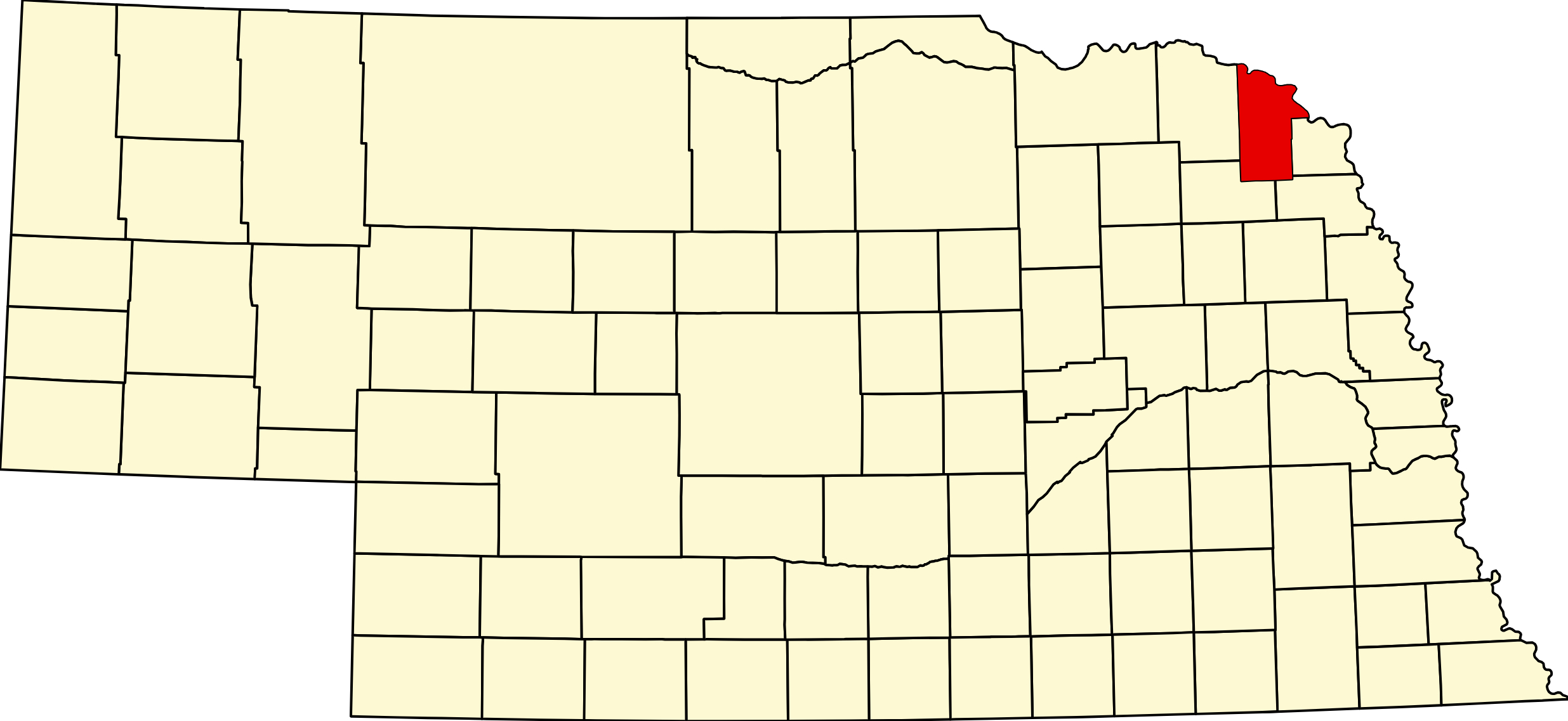
Dixon County, Nebraska
Northeast Nebraska · License Plate #35 · County Seat: Ponca
About Dixon County
Dixon County occupies the northeastern corner of Nebraska, bounded by the Missouri River to the east and north, Cedar County to the west, and Wayne and Thurston counties to the south. With the county seat at Ponca, the county covers 476 square miles of diverse terrain — from gently rolling farmland in the interior to the dramatic Missouri River bluffs of the northeast, one of the most scenic landscapes in the state.
The county is home to Ponca State Park, Nebraska's premier river-bluff recreation area, and sits adjacent to the Missouri National Recreational River, a federally protected stretch of one of North America's great rivers. The Lewis & Clark National Historic Trail follows the Missouri through the county, marking the route of the 1804–06 Corps of Discovery expedition. The county takes its name from Dixon, Illinois — the origin of an early territorial legislator — not from the village of the same name within the county.
Agriculture is the backbone of Dixon County's economy, with grain farming and livestock operations dominating the landscape. The county's nine active towns range from the county seat of Ponca (~893 residents) to the small village of Maskell (~65), each preserving a distinct identity within the broader agricultural community of northeast Nebraska.
Towns in Dixon County
Dixon County has nine active towns, each with its own page on Nebraska Directory. Browse the full town listing, population data, and town links:
Browse all Dixon County towns →
Direct town links: Ponca (county seat) · Emerson · Wakefield · Allen · Newcastle · Concord · Waterbury · Maskell · Dixon
Dixon County Cameras
Live cameras for Dixon County and the surrounding northeast Nebraska region are maintained on the Nebraska Cameras page.
Travel Corridors
Three major highways pass through Dixon County, connecting it to the broader northeast Nebraska region and the Missouri River corridor:
US-20 — the primary east-west highway through the county's southern tier, connecting Sioux City, Iowa to the west through Allen, Dixon village, and toward Cedar County. US-20 Corridor →
NE-35 — runs north–south through the western part of the county, connecting Newcastle in the north toward Wayne County in the south. NE-35 Corridor →
NE-12 — the scenic northeast Nebraska highway running through the county's northern tier, connecting Ponca and Maskell to Cedar County in the west and Dakota County in the east. NE-12 Corridor →
Dixon County Directory
Find businesses, services, and attractions in Dixon County through the Nebraska Directory:
Restaurants & Food · Lodging · Health Care · All Dixon County Listings →
Adjacent Counties
Cedar County (west) · Wayne County (south) · Thurston County (southeast) · Dakota County (east/north)
Iowa (across the Missouri River, northeast)
History
Dixon County was created by the territorial legislature on 26 January 1856 and organized as a separate county on 1 November 1858. Who it was named for is genuinely unknown — every source, including History Nebraska and the county itself, says only that it honours “an early pioneer” or “an early family of settlers”, and none names the person. Rather than repeat a guess, this page leaves it open.
Ponca, platted in 1856 and named for the Ponca people, won the county seat at the first county election on 12 December 1858, beating Ionia, Concord and North Bend. The county filled with farms along the Missouri bluffs and the Logan Creek valley, and the railroad towns of Allen, Wakefield, Emerson, Newcastle, Waterbury, Concord and Maskell followed.
Geography
Dixon County covers roughly 476 square miles in the extreme north-east corner of Nebraska, and its defining feature is the Missouri River bluff country — high wooded ridges standing several hundred feet above the floodplain, quite unlike the flat farmland further inland. The Missouri forms the northern and eastern boundary; Aowa Creek and Logan Creek drain the interior.
It borders Cedar County to the west, Wayne County to the south-west, Thurston County to the south and Dakota County to the east, with South Dakota and Iowa across the river to the north and north-east. From the bluffs at Ponca you can see three states at once.
Outdoors — Camping, RV, Hunting & Fishing
Ponca State Park is the anchor, and it is one of the best in the state — roughly 2,100 acres on the bluffs above the Missouri National Recreational River.
Camping and RV
Ponca State Park, 88090 Spur 26E. Three campgrounds: Turkey Ridge (35 Electric Plus, first come first served), Oak Bluff (37 Electric Plus, reservable) and Riverfront (20 sites, all reservable, reported at 30 and 50 amp). Basic non-electric sites year round, three group sites, and ten Tentrr canvas safari tents. Pull-throughs take rigs of 45 to 60 feet.
Dump and fill station on site. Water is from spigots near the loops — not hookups at the site. Twenty-seven cabins: fifteen four-bedroom mini-lodges, ten two-bedroom cottages and two straw-bale cabins year round, plus four rustic cabins April to mid-November.
Camping is year round but modern facilities run April to October only — you can get power in January, but not a shower. Half the electric sites are reservable up to a year ahead. A park entry permit is required, including to visit the Park Service education center inside the park.
Away from the park: Powder Creek WMA near Newcastle has primitive camping and restrooms, and takes RVs as well as tents, but no electric, no dump station, no potable water confirmed. Buckskin Hills WMA lists tent camping only and the sources disagree with each other — treat it as primitive. Elk Point Bend WMA north of Ponca has free dispersed camping with no facilities at all. Two National Park Service river accesses, Mulberry Bend and Ponca North Unit, allow primitive camping; the North Unit has no water.
Fishing
Powder Creek Reservoir — 107 acres, two miles east and three south of Newcastle, in Dixon County (some data sources wrongly file it under Cedar). Bluegill, channel catfish, largemouth bass, walleye, black crappie, flathead catfish and northern pike. Boat dock, 5 mph no-wake. Note that Game and Parks drew the reservoir down and renovated it from 2019, so the fishery is rebuilt and size structure differs from older reports.
Buckskin Hills Lake — 75 acres, two miles west and two south of Newcastle. Largemouth bass, bluegill, channel catfish, black crappie, walleye. Boat ramp, 5 mph no-wake.
Ponca State Park has a fishing pond plus three miles of Missouri River frontage, two boat ramps and a canoe launch — catfish, sauger, walleye and drum. The WMAs are free; Ponca requires a park entry permit even if you are only fishing or launching.
Hunting
Elk Point Bend WMA, about 1,600 acres north of Ponca along the Missouri, is the best-documented pheasant ground in this corner of the state — Game and Parks staff have counted around 150 birds on a single hunt. It is managed as early-successional prairie restoration.
Buckskin Hills WMA (340 acres) and Powder Creek WMA (467 acres), both Lewis & Clark NRD ground near Newcastle, carry pheasant, quail, deer, waterfowl and dove. All are free with no entry permit.
Trails and viewpoints
Ponca State Park has twenty-two miles of trail. Only the 2.5-mile paved Hike/Bike Trail is designated for bicycles — ten feet wide, running from the East Shelter House into the town of Ponca, and the right choice for strollers or anyone needing a firm surface. The others range from the 0.17-mile Education Center Nature Trail to the moderate-to-difficult 1.34-mile Corps of Discovery Trail.
The Three State Overlook takes in Nebraska, Iowa and South Dakota. The Missouri National Recreational River Resource and Education Center sits inside the park. The Ionia Volcano — a bluff that smoked and heated from oxidising shale, and was widely believed in the nineteenth century to be a volcano — has largely eroded into the river, but a state historical marker interprets the site. Ponca is the eastern terminus of the river’s 59-mile district and the eastern end of the Outlaw Trail Scenic Byway. Bald eagles winter here.
Events
The Dixon County Fair at Concord anchors the summer, and Ponca, Allen, Wakefield and Emerson each hold their own celebrations.
Dates move year to year, so they are kept with the listings rather than repeated here.
Browse event listings in Dixon County →
Submit an event or correction →
Dixon County at a Glance
Dixon County, Nebraska — about 476 square miles in the extreme north-east corner, where high wooded bluffs stand above the Missouri River. County seat Ponca, platted in 1856 and named for the Ponca people. 148 listings across 10 towns.
Getting there: NE-12, the eastern end of the Outlaw Trail Scenic Byway, begins at Ponca; US-20 crosses the south of the county; NE-9 and NE-15 run north to south.
For visitors: Ponca State Park — 2,100 acres of bluff country with twenty-two miles of trail, twenty-seven cabins, ninety-odd electric campsites and a Three State Overlook taking in Nebraska, Iowa and South Dakota. Two NRD lakes near Newcastle for fishing, and Elk Point Bend for pheasants.
Vehicles registered in Dixon County carry license plate number 35. See what every Nebraska county number means.
Dixon County Businesses & Places
148 listings in Dixon County.
Click a category to see the businesses.
Eat & Drink (2)
- Bob's Bar and Grill — Bar & Grill, Martinsburg
- R & D Catering — Catering, Allen
Outdoors & Recreation (6)
- Buckskin Hills WMA — Public Hunting Areas & WMAs, Maskell
- Elk Point Bend WMA — Public Hunting Areas & WMAs, Nebraska
- Mulberry Bend WMA — Public Hunting Areas & WMAs, Maskell
- Newcastle Campground — Campgrounds & RV Parks, Nebraska
- Ponca State Park — Campgrounds & RV Parks, Nebraska
- Powder Creek WMA — Public Hunting Areas & WMAs, Nebraska
Places to Visit (7)
- Cook Blacksmith Shop — History & Heritage Museums, Nebraska
- Cook Blacksmith Shop & Historical Adams House Museum — History & Heritage Museums, Nebraska
- Dixon County Museum - Allen — History & Heritage Museums, Allen
- Graves Library Museum — Specialty Museums, Nebraska
- Historic Chicago and Northwestern Depot Museum — History & Heritage Museums, Nebraska
- Ponca Historical Society and Museum/Blacksmith Shop — History & Heritage Museums, Nebraska
- Ponca State Park — RV Camping, Nebraska
Events & Venues (4)
- Allen Community Center Inc. — Community Center, Allen
- Allen Consolidated Schools Homecoming — Allen
- Dixon County Fair — County Fair, Concord
- Dixon County Fairgrounds — Fairground, Nebraska
Health & Emergency (2)
- Faith Health Wakefield Family Medicine — Medical Clinic, Nebraska
- Sanford Vermillion Ponca Clinic — Medical Clinic, Nebraska
Shopping & Gifts (2)
- The Quilt Shop — Fabric & Quilt Shop, Nebraska
- Two Dam Buffalo Meat — Butcher Shop, Allen
Community & Faith (44)
- Concord Cemetery — Concord — Cemeteries, Concord
- Concord EFC — Evangelical Free Church, Concord
- Concordia Lutheran Church — Lutheran Church, Concord
- Congregational UCC — Newcastle — Congregational Church, Nebraska
- Daily Branch Cemetery — Newcastle — Cemeteries, Nebraska
- Dewitt Cemetery — Ponca — Cemeteries, Nebraska
- Eastview Cemetery — Allen — Cemeteries, Allen
- Evangelical Lutheran Immanuel Cemetery — Wakefield — Cemeteries, Nebraska
- Faith Lutheran Church (Maskell) — Lutheran Church, Nebraska
- First Lutheran Church — Lutheran Church, Allen
- Gibb's Cemetery — Newcastle — Cemeteries, Nebraska
- Halverson Cemetery — Maskell — Cemeteries, Maskell
- Holmes Family Cemetery — Ponca — Cemeteries, Nebraska
- Immanuel Lutheran Church — Lutheran Church, Nebraska
- Ionia Cemetery — Newcastle — Cemeteries, Nebraska
- Jordan Cemetery — Allen — Cemeteries, Allen
- Lime Creek Cemetery — Maskell — Cemeteries, Maskell
- Lime Grove Cemetery — Maskell — Cemeteries, Maskell
- Marquis Cemetery — Waterbury — Cemeteries, Nebraska
- Martinsburg South Cemetery — Martinsburg — Cemeteries, Martinsburg
- Maskell Cemetery — Maskell — Cemeteries, Maskell
- Newcastle Cemetery — Newcastle — Cemeteries, Nebraska
- Pleasant Hill Cemetery — Allen — Cemeteries, Allen
- Ponca Cemetery — Ponca — Cemeteries, Nebraska
- Ponca EFC — Evangelical Free Church, Nebraska
- Ponca First UMC — Methodist Church, Nebraska
- Saint Annes Cemetery — Dixon — Cemeteries, Dixon
- Saint Pauls Lutheran Church Cemetery — Concord — Cemeteries, Concord
- Saint Peters Calvary Cemetery — Newcastle — Cemeteries, Nebraska
- Salem Lutheran Cemetery — Ponca — Cemeteries, Nebraska
- Salem Lutheran Church — Lutheran Church, Nebraska
- Silver Ridge Cemetery — Ponca — Cemeteries, Nebraska
- Southcreek Calvary Catholic Cemetery — Ponca — Cemeteries, Nebraska
- Springbank Friends Cemetery — Allen — Cemeteries, Allen
- St. Anne Mission Dixon — Catholic Church, Dixon
- St. John Lutheran Church — Lutheran Church, Nebraska
- St. Joseph Catholic Church Ponca — Catholic Church, Nebraska
- St. Paul Lutheran Church — Lutheran Church, Concord
- St. Peter Catholic Church Newcastle — Catholic Church, Nebraska
- Tara Hill Cemetery — Newcastle — Cemeteries, Nebraska
- Trinity Lutheran Cemetery — Martinsburg — Cemeteries, Martinsburg
- Trinity Lutheran Church (Martinsburg) — Lutheran Church, Nebraska
- United Methodist Church - Allen — Methodist Church, Allen
- Wakefield Cemetery — Wakefield — Cemeteries, Nebraska
Government & Resources (36)
- Allen Fire Station — Fire Station, Allen
- Allen Post Office — Post Office, Allen
- Concord Post Office - Dixon — Post Office, Dixon
- Concord Village Office — City Hall, Concord
- Concord-Dixon Senior Citizens, Inc. — Senior Citizen Center, Concord
- Dixon County Assessor — County Assessor, Nebraska
- Dixon County Attorney's Office — County Attorney, Nebraska
- Dixon County Clerk — County Clerk, Nebraska
- Dixon County Court — County Court, Nebraska
- Dixon County Courthouse — Court House, Nebraska
- Dixon County Driver License Office — County Driver License, Nebraska
- Dixon County Emergency Management — Emergency Management, Nebraska
- Dixon County Maintenance Shed — Maintenance Shed, Allen
- Dixon County Sheriff — County Sheriff, Nebraska
- Dixon County Treasurer — County Treasurer, Nebraska
- Dixon County Veterans Service Office — Veterans Office, Nebraska
- Dixon County Weed Superintendent — County Weed Control, Nebraska
- Dixon Fire and Rescue — Fire Station, Dixon
- Dixon Fire Department — Fire Station, Dixon
- Dixon Post Office — Post Office, Dixon
- Martinsburg Fire Hall — Fire Station, Martinsburg
- Martinsburg Village Office — City Hall, Martinsburg
- Maskell Village Office — City Hall, Maskell
- Newcastle Fire Department — Fire Station, Nebraska
- Newcastle Police Department — Police Station, Nebraska
- Newcastle Post Office — Post Office, Nebraska
- Ponca Carnegie Library — Libraries, Nebraska
- Ponca City Hall — City Hall, Nebraska
- Ponca Fire Department — Fire Station, Nebraska
- Ponca Police Department — Police Station, Nebraska
- Ponca Post Office — Post Office, Nebraska
- Ponca Senior Citizens Center, Inc. — Senior Citizen Center, Nebraska
- Ponca USDA Service Center — USDA Service Center (FSA/NRCS), Nebraska
- Springbank Library — Libraries, Allen
- Wakefield Elementary School Mobile Food Distribution — Mobile & Pop-Up Food Distribution, Nebraska
- Waterbury Village Office — City Hall, Nebraska
Education (12)
- Allen Consolidated School — School District (K-12 / General), Allen
- Allen Elementary School — Elementary & Middle School, Allen
- Allen High School — High School, Allen
- Dixon County Extension — County Extension Office, Concord
- Educational Service Unit 1 — Educational Service Unit, Nebraska
- Haskell Agricultural Laboratory — Research & Extension Center, Concord
- Ponca Elementary School — Elementary & Middle School, Nebraska
- Ponca High School — High School, Nebraska
- Ponca Public Schools — School District (K-12 / General), Nebraska
- Wakefield Elementary School — Elementary & Middle School, Nebraska
- Wakefield High School — High School, Nebraska
- Wakefield Public Schools — School District (K-12 / General), Nebraska
Utilities (8)
- City of Ponca — Water Utility / District, Nebraska
- Ponca Municipal Gas — Natural Gas Provider, Nebraska
- Village of Allen — Water Utility / District, Allen
- Village of Concord — Water Utility / District, Concord
- Village of Dixon — Water Utility / District, Dixon
- Village of Martinsburg — Water Utility / District, Nebraska
- Village of Newcastle — Water Utility / District, Nebraska
- Village of Waterbury — Water Utility / District, Nebraska
Agriculture & Farm (7)
- Big Red Farms — Poultry, Nebraska
- Broken Spur Ranch — Boarding Stable, Nebraska
- Christensen Well & Irrigation, Inc. - Wakefield — Well Drilling, Nebraska
- Dixon Elevator Company — Grain Elevator / Cooperative, Dixon
- Husker Pride Farms — Poultry, Nebraska
- Love A Lop Exotic Farm — Specialty / Niche Ag Producer, Allen
- M.G. Waldbaum Company — Poultry, Nebraska
Automotive (6)
- Countryside Gas N Grocery — Fuel & Gas Station, Allen
- Ekberg Auto — Auto Repair, Nebraska
- Full Circle Sales — Used Car Dealer, Nebraska
- Highway 9 Auto Sales — Used Car Dealer, Nebraska
- Rod’s Repair — Auto Repair, Allen
- Scott Hansens Automotive — Auto Repair, Concord
Professional Services (4)
- Anderson & Anderson Insurance — Insurance, Allen
- Pommer Accounting — Accountant, Nebraska
- Security Bank - Allen — Banking, Allen
- State Farm Insurance — Insurance, Allen
Media (4)
- KFHC 88.1 FM - Ponca — Radio Station, Nebraska
- KWTN 100.9 FM - Allen — Radio Station, Allen
- Nebraska Journal-Leader — News Paper, Nebraska
- Wakefield Republican — News Paper, Nebraska
Land & Property Services (1)
- Dirt Road Construction — Excavating Contractor, Allen
Personal Services (1)
- Lisa’s Salon — Beauty Salon, Allen
Trades & Construction (1)
- Mattes Construction — General Contractor, Allen
Manufacturing & Industrial (1)
- Oldenkamp Trucking — Trucking Company, Allen
Transportation (1)
- Wakefield Public Transportation Program — Public Transportation, Nebraska