Historic Marker

Displaying listings from all locations.

Use the fields below to filter listings for a particular country, city, or state. Start by selecting the top most region, the other fields will be automatically updated to show available locations.

Use the Clear Filter button if you want to start over.

Average Rating
(More feedback needed)
Listing Category
Short Description

The Chadron-Chicago Cowboy Race Historical Marker is on East 2nd Street in downtown Chadron.


Address
150 E. 2nd St.
Chadron, NE
69337
Listing Tags
State
Nebraska
Country
USA
County
Dawes County
Town
Chadron
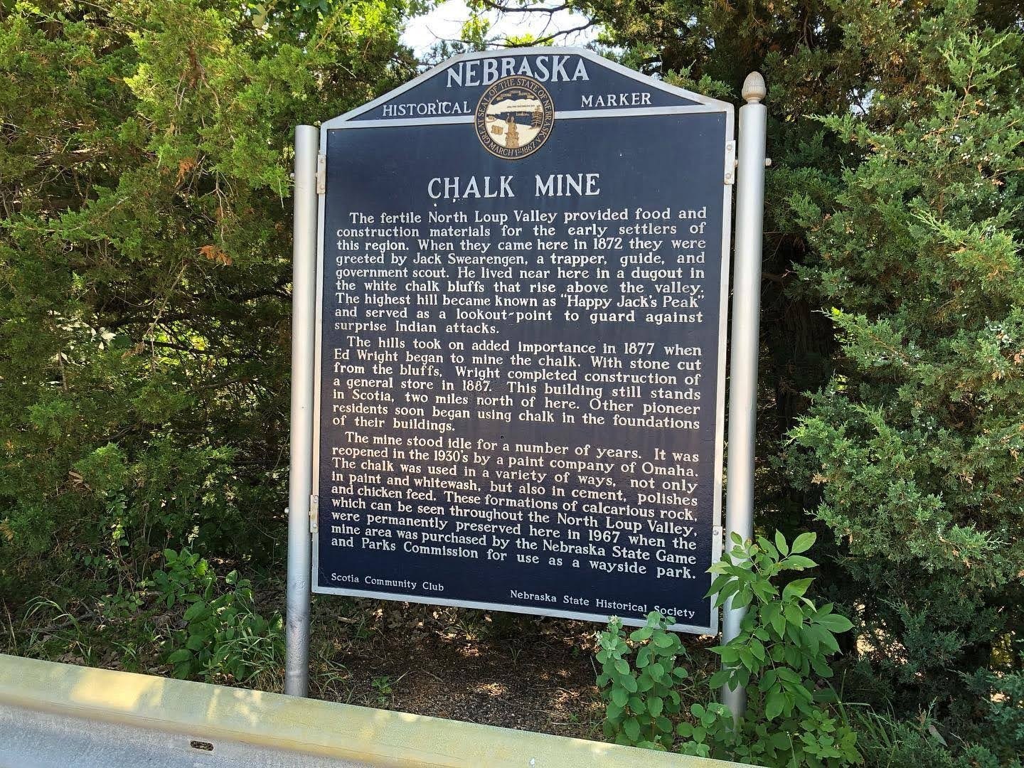
Chalk Mine Historical Marker
Average Rating
(More feedback needed)
Listing Category
Short Description

State marker on NE 11 south of Scotia about Happy Jack Peak and the chalk mine Ed Wright opened in 1877.


Address
NE 11, 2 miles south of Scotia
Scotia, NE
68875
Listing Tags
State
Nebraska
Country
USA
County
Greeley County
Town
Scotia
Average Rating
(More feedback needed)
Listing Category
Short Description

History Nebraska marker at Champion Mill, which it calls probably the oldest functioning water-powered mill in Nebraska.


Address
Mill St.
Champion, NE
69023
State
Nebraska
Country
USA
County
Chase County
Town
Champion
Average Rating
(More feedback needed)
Listing Category
Short Description

Cheyenne County Historical Marker is at the westbound Interstate 80 rest area near mile marker 61, about 2 miles east of Sidney's exit 59.


Address
I-80 westbound rest area, near mile 61, east of Sidney
Sidney, NE
69162
Listing Tags
State
Nebraska
Country
USA
County
Cheyenne County
Town
Sidney
Average Rating
(More feedback needed)
Listing Category
Short Description

The Civil War Memorial to the Unknown Dead stands on the Hamilton County Courthouse square in Aurora, on 12th Street north of L Street.


Address
Civil War Memorial to the Unknown Dead
Hamilton County Courthouse Square
Aurora, NE
68818
State
Nebraska
Country
USA
County
Hamilton County
Town
Aurora
Average Rating
(More feedback needed)
Listing Category
Short Description

The Clay Center historical marker from History Nebraska stands at 200 West Johnson Street in Clay Center.


Address
Clay Center Historical Marker
200 W Johnson St
Clay Center, NE
68933
State
Nebraska
Country
USA
County
Clay County
Town
Clay Center
Average Rating
(More feedback needed)
Listing Title
Listing Category
Short Description

Large pioneer ranches were established in this region of Nebraska in the 1870’s and early 1880’s.


Address
Coffee Siding Historical Marker
US 20, about 1 mi east of the Wyoming line
Harrison, NE
69346
Listing Tags
State
Nebraska
Country
USA
County
Sioux County
Town
Coffee Siding
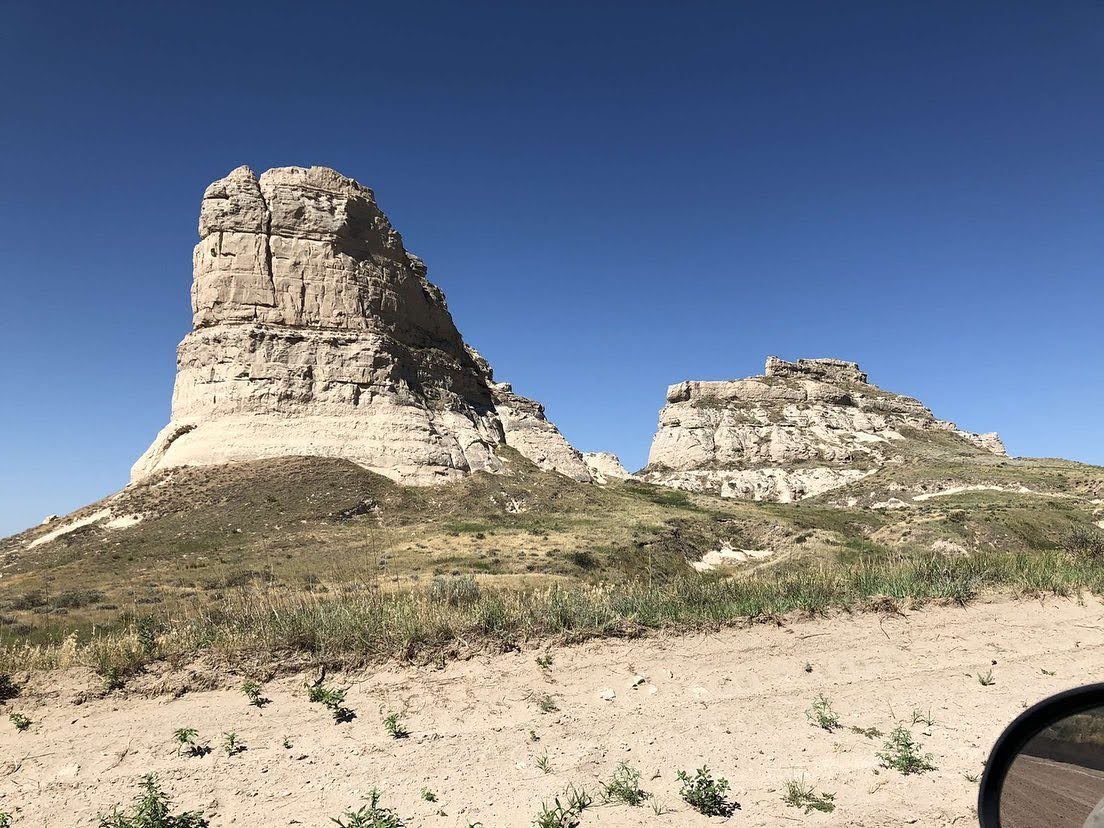
Courthouse and Jail Rocks
Average Rating
(More feedback needed)
Short Description

Twin trail landmarks on Highway 88 about 5 miles south of Bridgeport, rising some 400 feet above the North Platte Valley. Free, open in daylight.


Address
Highway 88, about 5 miles south of Bridgeport
Bridgeport, NE
69336
Listing Tags
State
Nebraska
Country
USA
County
Morrill County
Town
Bridgeport
Average Rating
(More feedback needed)
Listing Category
Short Description

Historical marker at the site of Cowles's three-story consolidated school, opened in 1915 and closed in 1959.


Address
Adams St. east of 5th St.
Blue Hill, NE
68930
Listing Tags
State
Nebraska
Country
USA
County
Webster County
Town
Cowles
Average Rating
(More feedback needed)
Listing Category
Short Description

Fort Robinson in Dawes County, Nebraska is the site where Lakota leader Crazy Horse was fatally stabbed in 1877 while being held as a prisoner.


Address
Crazy Horse Death Site Marker
Fort Robinson State Park, by the guardhouse and adjutant's office
Crawford, NE
69339
State
Nebraska
Country
USA
County
Dawes County
Town
Crawford
Average Rating
(More feedback needed)
Listing Category
Short Description

State historical marker in Culbertson on the 1873 trading post and the county's first seat, on the site of the 1886 courthouse.


Address
Arizona St., City Park
Culbertson, NE
69024
State
Nebraska
Country
USA
County
Hitchcock County
Town
Culbertson
Average Rating
(More feedback needed)
Listing Category
Short Description

Historical marker at the site of the Cumro post office (1885 to 1943).


Address
Cumro site, southern Custer County
Cumro, NE
68834
Listing Tags
State
Nebraska
Country
USA
County
Custer County
Town
Cumro
Average Rating
(More feedback needed)
Listing Category
Short Description

Milo F. Young's 1876 log ranch house, the county's temporary courthouse, in Morgan Park (National Register; marker No. 134).


Address
Morgan Park, Pacific St. and Cameron Ave.
Callaway, NE
68825
State
Nebraska
Country
USA
County
Custer County
Town
Callaway
Average Rating
(More feedback needed)
Listing Category
Short Description

State marker (No. 411) at Columbia Hall on the Danish founding of Dannebrog in 1871.


Address
Columbia Hall, NE 58
Dannebrog, NE
68831
State
Nebraska
Country
USA
County
Howard County
Town
Dannebrog
Average Rating
(More feedback needed)
Listing Category
Short Description

The Deep Well Irrigation historical marker on Q Street in Aurora tells how FE Edgerton sank a 225-foot irrigation well in 1931 and how deep-well irrigation helped farmers through the drought of the 1930s.


Address
Deep Well Irrigation Historical Marker
1201 Q St
Aurora, NE
68818
State
Nebraska
Country
USA
County
Hamilton County
Town
Aurora
Average Rating
(More feedback needed)
Listing Category
Short Description

Nebraska historical marker on US 75 for De Soto, the 1854 river town that was county seat from 1858 to 1866.


Address
US 75 at the former Fort Calhoun Station, north of Fort Calhoun
Fort Calhoun, NE
68023
Listing Tags
State
Nebraska
Country
USA
County
Washington County
Town
De Soto
Average Rating
(More feedback needed)
Listing Category
Short Description

State historical marker on US 275 for DeWitt, the first permanent settlement in Cuming County (1857), which lost the county seat to West Point in 1858.


Address
US 275, about 4 mi northwest of West Point
Beemer, NE
68716
Listing Tags
State
Nebraska
Country
USA
County
Cuming County
Town
DeWitt
Average Rating
(More feedback needed)
Listing Category
Short Description

The DeWitty historical marker, at the entrance to the Cherry County Historical Society Museum in Valentine, tells the story of DeWitty (later Audacious), the largest rural African American settlement in Nebraska.


Address
Cherry County Historical Society Museum, S. Main St. at US 20
Valentine, NE
69201
State
Nebraska
Country
USA
County
Cherry County
Town
Valentine
Average Rating
(More feedback needed)
Listing Category
Short Description

State marker on US 385 south of Gurley for the Mary Egging No. 1, the first successful oil well in western Nebraska, 1949.


Address
US 385, 0.3 mi south of Road 38, about 4 mi south of Gurley
Gurley, NE
69141
Listing Tags
State
Nebraska
Country
USA
County
Cheyenne County
Town
Gurley
Average Rating
(More feedback needed)
Listing Category
Short Description

State marker No. 530 for the former Etna community, on Etna Road east of NE 47.


Address
Etna Rd. just east of NE 47
Etna, NE
69138
Listing Tags
State
Nebraska
Country
USA
County
Custer County
Town
Etna