
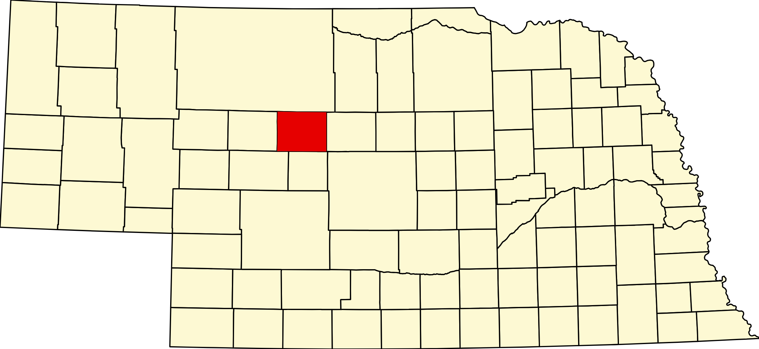
Thomas County, Nebraska
County Seat: Thedford
Founded: 1887
Named For: General George H. Thomas, Union Civil War general
License Plate Prefix: 89
Population: 669 (2020 census)
Area: 714 sq mi
History
Thomas County was established in 1887 and named after General George H. Thomas, a respected Union commander during the Civil War. Settlement in the region followed the expansion of ranching across the Sandhills, where the environment favored grazing over farming. Thedford, founded along the railroad, became the county seat and remains the county’s primary community and service center.
The county’s history is rooted in ranching culture, frontier settlement, and the development of small, resilient communities adapted to the Sandhills landscape. Generations of ranching families have shaped the county’s identity for more than a century.
Geography
Location: Central Sandhills region of Nebraska
Landscape: Sandhills dunes, rolling prairie, grasslands, and extensive ranchland
Adjacent Counties:
- Blaine County (east)
- Loup County (southeast)
- Custer County (south)
- Logan County (west)
- Hooker County (north)
Culture & Landmarks
- Middle Loup River Valley – Scenic corridor supporting wildlife, ranching, and recreation.
- Thedford Area Heritage Sites – Local landmarks tied to early settlement and railroad development.
- Sandhills Prairie – One of the most intact grassland ecosystems in North America.
Notable Communities
- Thedford – County seat and primary community.
- Halsey (shared with Blaine County) – Gateway to the Nebraska National Forest.
- Natick and Moyer – Small unincorporated rural communities.
Events & Attractions
- Thomas County Fair – Rodeo events, livestock shows, and community celebrations.
- Nebraska National Forest at Halsey – Hiking, camping, and outdoor recreation in one of the nation’s largest hand‑planted forests.
- Sandhills Ranching Heritage – Local events celebrating agriculture and rural traditions.
Living in Thomas County
Thomas County offers a quiet rural lifestyle centered around ranching, open landscapes, and strong community ties. Thedford provides essential services, while the county’s vast ranchlands define its character. Residents value the area’s peaceful pace, natural beauty, and deep connection to Nebraska’s Sandhills heritage.
Thomas County Road Map
Download the printable county road map (PDF, Nebraska Dept. of Transportation)
Outdoors — Camping, RV, Hunting & Fishing
Thomas County is the recreation county of the central Sandhills. The Nebraska National Forest — Bessey Ranger District is here: about 90,000 acres of national forest, of which roughly 20,000 acres is hand-planted — the largest human-planted forest in the United States. It was begun in 1902 by Dr. Charles E. Bessey of the University of Nebraska, who believed the Sandhills had once been forested and who, with Gifford Pinchot and Theodore Roosevelt, got the sandhills designated a forest reserve. The Charles E. Bessey Tree Nursery, also from 1902, is the oldest seedling nursery managed by the USDA and still operating. The Civilian Conservation Corps did much of the planting.
The Bovee Fire. On 3 October 2022 the Bovee Fire burned about 5,000 acres of the national forest — roughly a quarter of the planted forest — and jumped Highway 2 to burn some 14,000 to 15,000 acres of private rangeland. It destroyed the Scott Lookout Tower, and destroyed Eppley Lodge and ten camper cabins at the Nebraska State 4-H Camp, open since 1963. Mike Moody, 59, assistant chief of the Purdum Volunteer Fire Department, died during initial attack. Aggressive defence saved the Bessey Recreation Complex and the nursery. The Forest Service has not committed to replanting in kind. Visitors should expect a landscape of blackened trees still standing in their original planted rows — and the Scott Lookout Tower site is open for viewing but the tower may not be entered. The trailhead for the roughly 2½-mile Scott Tower Hiking Trail is about half a mile from Bessey Fish Pond.
Fire restrictions: Stage 1 fire restrictions are in effect across all Nebraska National Forests and Grasslands under Forest Order 02-07-00-26-12, effective 18 July 2026. Verify current status before planning a campfire — Supervisor’s Office (308) 432-0300. Camping in one ranger district is limited to 14 nonconsecutive nights in any 30-day period, and certified weed-free forage is required for stock.
Bessey Recreation Complex and Campground. 40637 River Loop, Halsey — district office (308) 533-2257; reservations at recreation.gov or 877-444-6777, up to six months ahead. On the Middle Loup River, about 16 to 17 miles east of Thedford.
- Roughly 44 to 48 campsites across four loops plus a group site and a picnic shelter. Two ADA-compliant sites.
- Electric hookups at the group site and about half the standard sites. Amperage is not published by the Forest Service; third-party reports say 20/30/50 — assume 30-amp and carry adapters.
- Potable water year round at the recreation building only, not at individual sites. Seasonal spigots elsewhere mid-May to mid-October.
- One flush-toilet and shower building, open mid-May to mid-October. Three vault toilets year round. Showers are reported free.
- Fees: non-electric $15, electric $20, group site $125. Day use $5 per vehicle, $20 annual pass.
- Camping is available all year, open 24/7, checkout 2 p.m. Central. About half the sites are reservable mid-May to mid-October; the rest are first come, first served year round.
- One trailer per site — an RV and a trailer cannot share a site. Two vehicles per site. No pull-throughs. Several walk-to tent-only sites.
- Length limit is not published by the Forest Service; third-party reports range from 27 feet to 50. Call before bringing a big rig.
- On site: picnic tables, fire rings, campground host in season, basketball court, horseshoe pits, and a pedestrian bridge over the Middle Loup. There is no swimming pool — the historic pool is gone, and swimming happens in the river.
The dump station question — call ahead. The official Forest Service page for the campground does not list a dump station and one camping database says there is none, while several others say there is. Do not plan your trip around dumping at Bessey. Call the district at (308) 533-2257. No confirmed public dump station exists anywhere else in Thomas County either.
Bessey Fish Pond. A seven-acre pond just north of the Middle Loup, about 17 miles east of Thedford, with its own gravel parking area. Stocked by Game and Parks with trout, catfish, bluegill and bass. ADA-accessible fishing pier; fish from the pier, the shoreline, a non-motorized boat, or through the ice in winter. A Nebraska fishing permit is required, plus the $5 day-use fee or $20 annual pass. Open year round, 24/7. Swimming is prohibited — underwater hazards.
Natick Campground. About 17 miles east of Thedford on Highway 2, then south on State Spur 86B and roughly 7 miles on Forest Road 212. 17 units and 20 corrals for riding stock. First come, first served, no reservations. No hookups and no potable water — there is a hand pump for non-potable water only, so bring your own drinking water. Modern vault toilets, tables, fire rings. $15 a night by fee envelope within 30 minutes of taking a site. Open year round. ATVs and side-by-sides are prohibited at Natick. It sits on the seam between planted forest and native grassland, and the Forest Service specifically calls out its outstanding night-sky viewing.
Whitetail Campground. Southeastern corner of the district, on the Dismal River. 10 units and 9 horse corrals, first come first served. No electricity, no potable water — hand pump, non-potable. Modern vault toilets. $15 a night by envelope. Open year round. Access matters here: Forest Road 277 is closed for resource protection, so the route in is State Spur 86B to Forest Road 203 south to Forest Road 224 east — roughly 24 miles of sand and dirt forest road from Halsey. Not a route for a big rig or a low-clearance tow vehicle. It sits on the OHV system, so expect daytime machine noise. Some directories give a Dunning mailing town, which is in Blaine County — the campground itself is in Thomas County.
Bessey OHV Trail System. About 36 miles of designated OHV trail through forest and grassland — deep sand, straightaways and curves. Vehicles must be 64 inches wide or less and must stay on designated routes per the Motor Vehicle Use Map. Two open riding areas, Hill Climb and the Dismal. Trailheads at the main Bessey lot, the Dismal Trailhead at the end of Scenic Road, Whitetail Campground and the Powerline Trailhead. $5 per vehicle at the main lot, $20 annual; no fee at Powerline or Dismal. Campground guests pay no additional trail fee.
Thedford City Park and Campground. Around 3rd and Court Streets. Four or five RV spots with 30-amp electric plus roughly seven to ten tent spaces, multiple water spigots, picnic tables, fire rings, dumpster and playground. FREE — donation requested, box near the pavilion. Open year round. No dump station. A flush toilet is reported about a hundred yards east on the far side of the ballfield. Longest rig reported 41 feet, though reviewers say 20 to 26 feet fits comfortably. Expect noise — roughly eight trains a day plus Highway 2 truck traffic.
Also in Thedford: Sandhill River Trips, 608 Court St. — canoe, kayak, tanking and tubing. Thedford Golf Course, nine holes, one mile south on US-83. The Thomas County Historical Museum at 609 Court St. and the Thedford Art Gallery at 509 Court St. And on the Courthouse Square at Main and Walnut, the “Little Girls Lost” historical marker and life-size bronze, commemorating the two Haumann sisters lost in the Sandhills in May 1891 — accessible day and night.
Hunting. The Bessey Ranger District is open to hunting and is the largest block of genuinely public hunting ground in the central Sandhills; dispersed camping is permitted on most forest land, up to 14 days. No state wildlife management area is confirmed in the county. Wildlife documented at Bessey includes prairie chicken, mule deer, white-tailed deer, pronghorn, eagles and hawks, and spring prairie-grouse viewing blinds are set up on the district for watching sharp-tailed grouse and prairie-chicken on their dancing grounds in late March and April — a real draw.
Thomas County at a Glance
Thomas County, Nebraska — created and organized in 1887 and named for the Civil War general George H. Thomas, the Rock of Chickamauga. The first homestead claim in the area was filed in 1880; the Burlington built through in 1887 and set five stations inside the county, among them Halsey, Thedford and Seneca. Thedford became county seat when the railroad reached it, and the present courthouse dates from 1922. The Kinkaid Act boom took population from 517 in 1890 to a peak of 1,773 in 1920; sandy soil and scarce water defeated the farmers, and by 1940 fourteen ranches averaged nearly 3,500 acres each. 61 listings across 6 towns.
Getting there: the Sandhills Journey National Scenic Byway, Highway 2, runs east and west through Halsey, Thedford and Seneca with the BNSF main line beside it; US-83 crosses north and south at Thedford between North Platte and Valentine.
For visitors: this is the recreation county of the central Sandhills. The Nebraska National Forest — Bessey Ranger District holds about 90,000 acres including the largest hand-planted forest in the United States, begun in 1902, along with the oldest USDA seedling nursery still operating. Bessey Recreation Complex is the only substantial developed campground between Broken Bow and Alliance; Natick and Whitetail add primitive camping with horse corrals, and 36 miles of OHV trail run through the district. Bessey Fish Pond is stocked and has an ADA pier. The Middle Loup crosses the middle of the county and the Dismal the south; they meet just east of Dunning. Visitors should know that the Bovee Fire of October 2022 burned a quarter of the planted forest and took the Scott Lookout Tower and a firefighter’s life.
Seneca is one of the country’s best-documented cases of a town voting itself out of existence — residents voted 17 to 16 in May 2014 to dissolve the village.
Thomas County · Sandhills · Highway 2 Corridor · Explore Nebraska
Vehicles registered in Thomas County carry license plate number 89. See what every Nebraska county number means.
Thomas County Businesses & Places
61 listings in Thomas County.
Click a category to see the businesses.
Eat & Drink (4)
- Anthem Coffee — Cafe / Coffee Shop, Nebraska
- Anthem Coffee Company — Cafe / Coffee Shop, Nebraska
- Lewi & Philly Red Brick Bar — Bar & Grill, Nebraska
- Sandhills Corral — American Restaurant, Nebraska
Stay (2)
- Arrowhead Lodge & Cafe — Motel, Nebraska
- Roadside Inn — Motel, Nebraska
Outdoors & Recreation (3)
- Antelope Valley Outfitters — Guides & Outfitters, Nebraska
- Redwood Inn Campground — Campgrounds & RV Parks, Halsey
- Seven Pines Ranch River Retreat — Campgrounds & RV Parks, Nebraska
Places to Visit (3)
- Charles E. Bessey Tree Nursery — National Forests & Grasslands, Halsey
- Nebraska National Forest – Bessey Ranger District — National Forests & Grasslands, Halsey
- Thomas County Historical Museum — History & Heritage Museums, Nebraska
Events & Venues (1)
- Thomas County Fairgrounds — County Fair, Nebraska
Shopping & Gifts (2)
- Bar None Hat Company — Western Wear & Outdoor Apparel, Nebraska
- Ewoldt's Grocery — Grocery, Nebraska
Government & Resources (21)
- Halsey Fire Department — Fire Station, Halsey
- Halsey Post Office — Post Office, Halsey
- Halsey Village Office — City Hall, Halsey
- Thedford Post Office — Post Office, Nebraska
- Thedford USDA Service Center — USDA Service Center (FSA/NRCS), Nebraska
- Thedford Village Office — City Hall, Nebraska
- Thedford Volunteer Fire & Rescue — Fire Station, Nebraska
- Thomas County Assessor — County Assessor, Nebraska
- Thomas County Attorney's Office — County Attorney, Nebraska
- Thomas County Clerk — County Clerk, Nebraska
- Thomas County Court — County Court, Nebraska
- Thomas County Courthouse — Court House, Nebraska
- Thomas County Driver License Office — County Driver License, Nebraska
- Thomas County Emergency Management — Emergency Management, Nebraska
- Thomas County Library — Libraries, Nebraska
- Thomas County Mobile Food Distribution — Mobile & Pop-Up Food Distribution, Halsey
- Thomas County Sheriff — County Sheriff, Nebraska
- Thomas County Treasurer — County Treasurer, Nebraska
- Thomas County Veterans Service Office — Veterans Office, Nebraska
- Thomas County Weed Superintendent — County Weed Control, Nebraska
- Upper Loup Natural Resources District – Thedford Office — Natural Resources District (NRD), Nebraska
Community & Faith (9)
- Amazing Grace Church — Non-Denominational Church, Nebraska
- Bethel Assembly of God — Pentecostal, Nebraska
- First Congregational UCC — Seneca — Congregational Church, Nebraska
- Hillcrest Cemetery — Thedford — Cemeteries, Nebraska
- Seneca Cemetery — Seneca — Cemeteries, Nebraska
- St. Thomas of Canterbury Catholic Church — Catholic Church, Nebraska
- The United Church of Christ — Halsey — Congregational Church, Halsey
- Trinity Lutheran Church — Lutheran Church, Nebraska
- United Church of Christ – Thedford — Congregational Church, Nebraska
Education (5)
- Central Sandhills Extension — County Extension Office, Nebraska
- Elementary School at Halsey — Elementary & Middle School, Halsey
- Thedford Elem Attendance Cntr — Elementary & Middle School, Nebraska
- Thedford High School — High School, Nebraska
- Thedford Public Schools — School District (K-12 / General), Nebraska
Automotive (3)
- Conoco Thedford — Conoco, Nebraska
- Sinclair Dino Mart – Sandhill Oil — Sinclair, Nebraska
- Sinclair Gas Station Thedford — Sinclair, Nebraska
Trades & Construction (2)
- Neben Construction — Construction, Nebraska
- Thedford Lumber & Supply — Lumber, Nebraska
Professional Services (2)
- Security First Bank – Thedford — Banking, Nebraska
- Western Nebraska Bank – Thedford — Banking, Nebraska
Utilities (1)
- Consolidated Telephone Company — Telephone & Internet Provider, Nebraska
Agriculture & Farm (1)
- Prairie Feed Supply — Feed & Farm Supply Store, Nebraska
Transportation (1)
- Thomas County Airport — Thedford — Municipal / General Aviation Airport, Nebraska
Media (1)
- Thomas County Herald — News Paper, Nebraska