
Fort Kearny Hike-Bike Trail: Across the Platte on an 1871 Railroad Bridge
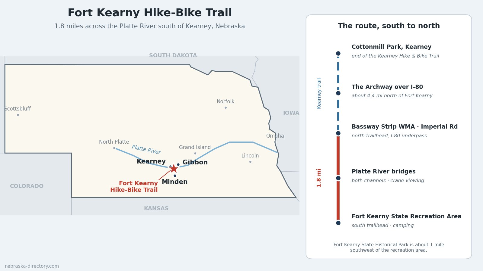
The Fort Kearny Hike-Bike Trail is a short, flat, paved path that crosses both channels of the Platte River on a former railroad bridge south of Kearney. It runs 1.8 miles from Fort Kearny State Recreation Area north to Bassway Strip Wildlife Management Area near Interstate 80, where it joins the Kearney Hike and Bike Trail. Together the two make a route of about 13 miles from Fort Kearny into Kearney. In March the bridge is one of the best public places in Nebraska to watch sandhill cranes come in to roost on the river.
Trail at a Glance
- Length: 1.8 miles, from Fort Kearny State Recreation Area to Bassway Strip WMA. Continuing on the Kearney Hike and Bike Trail, it is about 13 miles to Cottonmill Park in Kearney.
- Surface: Paved and flat, including the long bridge deck over the Platte.
- Uses: Walking, hiking, biking, wildlife watching, and cross-country skiing in winter. Dogs must be on a leash no longer than 6 feet.
- Permit: A Nebraska park entry permit is required for any vehicle parked at Fort Kearny State Recreation Area.
- Counties: The south end is in Kearney County. The river channels and the north end are in Buffalo County, whose line follows the south channel of the Platte.
- Nearest towns: Kearney, Minden and Gibbon.
Trailheads and Parking
South trailhead: Fort Kearny State Recreation Area. From I-80 exit 279 (Minden), take Nebraska Highway 10 south about 3 miles, then Link 50A west about 2 miles. The trail starts from the recreation area, which is about a mile east and a mile north of Fort Kearny State Historical Park. Park entry permit required.
North trailhead: Imperial Road. A small parking lot near the I-80 underpass at Imperial Road and Three Bridges Road, at the Bassway Strip end, where the trail meets the Kearney Hike and Bike Trail.
From Kearney: The Kearney Hike and Bike Trail has parking at Cottonmill Park (2795 Cottonmill Ave.), Yanney Heritage Park (2020 W. 11th St.) and the Archway (3060 E. 1st St.). From the Archway it is about 4.4 miles south to Fort Kearny.
What You'll See
The Platte River bridges. The trail crosses both channels of the Platte on what was a segment of the Burlington and Missouri River Railroad's Kearney-to-Kenesaw branch. The main bridge is nearly 1,000 feet long. The bridge over the north channel burned in a wildfire in 2009 and was replaced in 2017. The south bridge reopened in February 2026 after a renovation that added new decking, railings and viewing platforms.
Sandhill cranes. Crane season runs from early March to early April and usually peaks around the third week of March, when as many as 20,000 cranes roost on the river near the bridge. The best viewing is from a half hour before sunrise and around sunset. Stay quiet and keep lights off, as the birds flush easily. The covered gazebo and the bridge platforms give a clear view of the channel.
Other wildlife. Bald eagles winter along the river in January and February, American woodcocks perform their display flights near the bridge in March, and orioles, warblers and kingfishers turn up in spring and summer.
History Along the Trail
Fort Kearny, begun in 1848 and first called Fort Childs, was the first Army post built to protect travelers on the Oregon and California trails. The trails coming west from the Missouri River met near here to form the Great Platte River Road. The fort was abandoned in 1871 and became a state park in 1929; its reconstructed stockade, blacksmith shop and interpretive center are at Fort Kearny State Historical Park.
The railroad came next. The first railroad bridge here was built in 1871, and the Burlington's line met the Union Pacific at what became Kearney Junction in 1872. The last train on the Kearney-to-Kenesaw line ran in November 1976. The Fort Kearny Preservation, Restoration and Development Board bought the 1.8-mile segment and donated it to Nebraska Game and Parks, which turned it into the trail.
Nearby Places
- Fort Kearny State Historical Park — the 1848 fort, interpretive center and grounds, 1020 V Rd.
- Fort Kearny State Recreation Area — year-round camping, seven fishing lakes and a swimming beach in summer
- Bassway Strip Wildlife Management Area — river woodland at the north end of the trail
- Rowe Sanctuary (Iain Nicolson Audubon Center) — guided crane blinds in season, near Gibbon
- Crane Trust Nature and Visitor Center — trails and crane viewing near Wood River
- Windmill State Recreation Area — camping off I-80 at Gibbon
- The Archway — the Great Platte River Road museum over I-80 in Kearney
Plan Your Visit
- Hours: Fort Kearny State Historical Park is open 8 a.m. to sunset year-round. Its interpretive center keeps seasonal hours, and admission is charged there.
- Crane season: Plan on sunrise or sunset in March, and dress warmly; it is cold on the open bridge.
- Camping: Fort Kearny State Recreation Area has campsites at the trailhead. See RV & Camping in Nebraska for more.
- Permits: Buy a Nebraska park entry permit online from Nebraska Game and Parks or at the park.
Related Trails and Corridors
- Oregon National Historic Trail
- California National Historic Trail
- Great Platte River Road
- Nebraska Highway 44 — passes the road to Fort Kearny
- US Highway 30 and Interstate 80 — through Kearney
- ← All Nebraska Trails